Happening Now is a feature designed to bring updates, announcements and info on news items throughout the day. You are invited to participate. See a road closure? A business opening? A smoke plume? Storm-related mishaps like downed trees, power lines, road or other flooding? Email us at news@yubanet.com or call 530-478-9600 to let us know. You can also text us reports to 530-409-9888, but please don’t text or call while driving.
October 31, 2019 at 9:13 PM No injuries reported for the accident on Hwy 20 near Red Lane, car off the roadway.
October 31, 2019 at 8:59 PM Vehicle accident, Hwy 20 and Red Lane, Rough&Ready, units en route.
October 31, 2019 at 7:40 PM TNF units at scene on Gold Lake Hwy report a tree stump on fire only, no spread or potential for growth. They will knock this down soon. Downieville Fire is also on scene.
October 31, 2019 at 7:07 PM Reported small fire off Hwy 49 on Gold Lake Hwy near Bassetts. Possible power lines down, units en route.
October 31, 2019 at 9:50 AM Non-injury accident on Bitney Springs Road, not East Bennett in Grass Valley, as originally reported – School bus vs embankment. The kids are fine.
October 31, 2019 at 9:21 AM The report of smoke was unfounded.
October 31, 2019 at 9:12 AM Report of smoke seen on Carrie Drive and Lorie Drive in Alta Sierra, units en route.
October 31, 2019 at 7:31 AM Chilly morning with a chance of ghosts and goblins tonight. Clear skies and dry air will make for cool evening temperatures for Trick or treating this evening. By mid evening, valley temperatures will drop into the 50s with 40s possible in the foothills. Make sure those little ghosts and goblins stay warm.
October 31, 2019 at 12:16 AM The 10 by 10 spot on Sky Pines has been fully extinguished.
October 31, 2019 at 12:12 AM First units are at scene on Sky Pines.
October 31, 2019 at 12:05 AM Small spot on the 14800 block of Sky Pines Road in Grass Valley, reported as a 10 by 10 spot. Units en route.
October 30, 2019 at 11:26 PM All units have been released from the Streeter incident. Small spot has been contained.
October 30, 2019 at 10:53 PM Additional water tender has arrived at the Streeter incident. Firefighters are making good progress.
October 30, 2019 at 10:45 PM Report of a roadside fire on Hwy 49 near Streeter Road. Units on scene.
October 30, 2019 at 1:41 PM Fire on Rainbow Valley Ln has been contained.
October 30, 2019 at 1:10 PM Report of a small vegetation fire on Rainbow Valley Lane off Hwy 193 in Newcastle, units en route.
October 30, 2019 at 12:46 PM As this PSPS draws to a close, keep your local community in mind. Many of us have not yet been restored, all of us have been affected. Rest, spend time with friends and family and if you can, support the local businesses and their staff.
October 30, 2019 at 12:41 PM No fire visible in Penn Valley, classified as a false alarm.
October 30, 2019 at 12:28 PM Some units are staging on Hwy 20 and Rough&Ready Hwy, please use caution in the area.
October 30, 2019 at 12:14 PM Report of flames seen on Golden Stair Way, between Indian Springs Road and Western Gateway Park. Full wildland dispatch en route.
October 30, 2019 at 11:26 AM Sierra Theaters celebrates its 40th anniversary with a free showing of E.T. The Extra-Terrestrial tonight at Del Oro Theatre. The event is going forward as planned – Del Oro Theatre has power! However tonight’s event is SOLD OUT – there are no more tickets available. Patrons must have a ticket to enter the show. Doors open at 6:30 PM, the show starts at 7:00 PM.
October 30, 2019 at 5:14 AM Decreasing fire weather concerns, chilly mornings ahead. A couple chilly mornings ahead across the region with lows around 6 to 12 degrees below normal. Near freezing temperatures are likely in the Valley with some teens into the mountains.
October 29, 2019 at 6:24 PM The fire on Old Tunnel is fully contained at approximately 1/4 acre. Engines are being released back to their units, with one engine and a Washington Ridge crew remaining on scene to mop up. They will be working in the area for several hours old Tunnel Road remains closed at this time.

October 29, 2019 at 5:43 PM Good progress being made at the fire on Old Tunnel Road. Starting to release some resources
October 29, 2019 at 3:25 PM Fire on Old Tunnel Road and Banner Lava Cap. Full wildland dispatch on scene,
October 29, 2019 at 3:25 PM Firefighters are making good progress on the Marcella fire near Bell Road, mopping up now.
October 29, 2019 at 3:09 PM Helicopter flying low over North San Juan for the past hour has been confirmed as a PG&E helicopter doing inspection work for vegetation management projects.
October 29, 2019 at 3:04 PM Vegetation fire on Joeger Road near Bell Road in Auburn. Full wildland dispatch on order.
October 29, 2019 at 11:11 AM Side incident can be handled with resources on site.
October 29, 2019 at 10:59 AM Side IC reports approximately 1/8th of an acre in duff and litter. Low growth potential.
October 29, 2019 at 10:56 AM No fire on Lone Lobo Trail, lines down only.
October 29, 2019 at 10:55 AM Report of a vegetation fire in Side Bet Drive, near You Bet Road, Peardale/Chicago Park area. Full wildland dispatch en route.

October 29, 2019 at 9:29 AM NWS update: Another round of dry and windy north winds is developing this morning and will continue through Wednesday afternoon. This combined with extremely low humidity will create critical fire weather conditions, with a Red Flag Warning in effect for most areas. While weaker than the recent weekend event, wind gusts will likely range from 35 to 50 mph across the region, locally higher in wind prone areas. From Thursday into the weekend, winds will become lighter as high pressure builds although humidities remain low.
October 29, 2019 at 9:26 AM Lines down on Lone Lobo Trail in Grass Valley. Units en route.
October 29, 2019 at 5:54 AM Red Flag Warning today through Wednesday afternoon, breezy north winds again. A Red Flag Warning is in effect for much of the region from 8 AM Tuesday through 4 PM Wednesday. Strong north to northeast winds and very low humidities are likely during this time frame.
October 29, 2019 at 5:40 AM Camptonville School will be in session today with a late start (2 hour delay).

October 28, 2019 at 8:52 PM Grass Valley Fire Engines 1 and 2, Nevada County Consolidated Water Tender 88, along with Penn Valley and CalFire worked the residential structure fire on the 16000 block of Gleko Rd. During initial attack Firefighter Cisneros saved the family pet!
October 28, 2019 at 6:42 PM Gleko IC says resources will be on scene for several hours to mop-up. Knockdown on the barn structure is complete.
October 28, 2019 at 6:40 PM Long Fire is contained, some mop-up still ongoing.
October 28, 2019 at 6:35 PM Gleko IC reports good progress. Firefighters contained the vegetation fire to a 30 by 30 spot, the threat to the home has been mitigated. They are able to handle with the resources at scene.
October 28, 2019 at 6:23 PM Structure fire on Gleko Road has spread to the vegetation.
October 28, 2019 at 6:19 PM Report of a structure fire on Gleko Road near Rough&Ready Hwy. Numerous resources en route.
October 28, 2019 at 6:16 PM Firefighters report some extension to the wildland on the Long Fire, making progress.

October 28, 2019 at 6:08 PM Long IC thinks they’ll be able to pick this up quickly with a few additional engines.
October 28, 2019 at 6:03 PM Augmented dispatch for a travel trailer on fire on Long Valley Road, in the Penn Valley area.
October 28, 2019 at 6:00 PM Dark smoke seen on Long Valley Road near Flying T Road.
October 28, 2019 at 5:35 PM Caller reports seeing smoke in the area on the north side of I-80 just west of Rollins Lake. Units en route.
October 28, 2019 at 3:43 PM Reported accident on Hwy 49 near Shoshoni is not a collision. Bicyclist ran into the ditch.

October 28, 2019 at 3:42 PM NWS Sacramento update: Lighter winds expected through the rest of today, though humidities will remain extremely low. The next round of dry and windy north winds likely to start early Tuesday morning continuing through at least Wednesday afternoon. This combined with extremely low humidity will create critical fire weather conditions, resulting in a Red Flag Warning. While weaker than the recent weekend event, wind gusts will likely range from 35 to 50 mph across the region, locally higher in wind prone areas. A Wind Advisory has been issued. Locally breezy conditions are possible across Sierra foothill locations into Wednesday night. From Thursday into the weekend, winds will become lighter as high pressure builds although humidities remain low.
October 28, 2019 at 3:39 PM Vehicle accident on Hwy 49 at Shoshoni Trail, reported as car vs bicyclist. Emergency services en route.
October 28, 2019 at 3:37 PM Roadway is blocked after a vehicle spun out on Nevada City Hwy at Ridge Road, use caution in the area.
October 28, 2019 at 3:24 PM One lane of Brewer Road is now open, firefighters are mopping up the structure fire. Please watch for equipment.
October 28, 2019 at 2:27 PM Firefighters are making good progress on the structure fire and have achieved knockdown. Canceling all water tenders, there is a hydrant nearby.
October 28, 2019 at 2:24 PM First unit on Brewer reports minimal extension to the vegetation, structure is a two-story building, well-involved. Air Attack requested over the incident to monitor for any extension to the wildland.
October 28, 2019 at 2:19 PM Report of a structure fire with possibly vegetation involved on the 16000 block of Brewer Road. Full wildland dispatch en route.
All information on this weekend’s wind/fire event, including road reports and the possible blackout will be posted here: https://yubanet.com/featured/psps5/
October 28, 2019 at 1:57 PM Power is back on in downtown Nevada City.
October 28, 2019 at 1:50 PM Firefighters have contained a small fire to less than 1 acre near the Pine Grove Reservoir on Birchville Road on the San Juan Ridge. Caused by a tree falling operation, tree hit a transformer.
October 28, 2019 at 12:53 PM
Placer County SO received a vague call of a small plane with hydraulics issues and the caller stated they would go down in Rollins Lake. Units are searching for any signs, so far they are unable to locate.
October 28, 2019 at 12:45 PM
Firefighters are at the Orchards Springs Campground on Rollins Lake after a report of a possible small plane down. They are attempting to locate, so far nothing showing. Aircraft en route to search the lake.
October 28, 2019 at 8:28 AM
Nevada County OES update: PG&E has given the “all-clear” and begun restoration of power lines in Nevada County as of 7:00 AM this morning, 10/28. Duration of restoration will be dependent on level of damages sustained during the wind event. Downed power lines and trees may likely impact rate of restoration.
We want to continue to remind people that once your power is restored, take the opportunity to prepare for the next possible event. Fire weather conditions are predicted Tuesday through Wednesday with the possibility for another Public Safety Power Shutoff. Refuel cars and generators, stock up on supplies and withdraw cash while the ATM’s have power. Make sure your Go Bag is ready and your car is parked towards the road, and take a moment to check in with friends, family and neighbors to see if they have any needs you may be able to help with.
The following PG&E Community Resource Centers (CRC) will be open today, 10/28, at 8AM:
• Sierra College: 250 Sierra College Dr, Grass Valley, CA
• Nevada City Elks Lodge: 518 CA-49, Nevada City, CA
• Former Penn Valley Community Church: 11739 Spenceville Road, Penn Valley, CA
• Gold Country Fairgrounds: 209 Fairgate Rd, Auburn, CA
October 28, 2019 at 6:53 AM Units have thoroughly checked the area, nothing showing.
October 28, 2019 at 6:44 AM Report of a possible vegetation fire, single report only, in the area of Little Deer Creek Lane and Logans Run in Grass Valley. The caller reports looking south and seeing flames. Units are en route.
October 28, 2019 at 6:31 AM Wind event winds down early, more concerns for Tuesday and Wednesday. Another round of gusty northerly wind is expected Tuesday into Wednesday. This event will likely not be as strong as this past weekend’s wind event.
October 28, 2019 at 5:59 AM A small spot, 6/10th of an acre, in the Deer Creek ravine below Twin Cities Church in Grass Valley is fully contained. Firefighters are finishing mop-up operations.
October 27, 2019 at 3:12 PM
Cruzon Air Attack reports less than 1/4 acre, slow rate of spread. Tahoe engines are en route to this. Air Attack will now check the Dorsey Fire.
October 27, 2019 at 2:54 PM New possible incident on Cruzon Grade near Backbone on the San Juan Ridge, units are arriving at scene, more TNF units en route.
October 27, 2019 at 1:48 PM Updates on the Dorsey Fire will be posted here: https://yubanet.com/Fires/dorsey/
October 27, 2019 at 1:26 PM Vegetation fire near the intersection of Dorsey Drive and Sutton Way, numerous resources assigned. Updates on the PSPS page
October 27, 2019 at 10:54 AM Damaging Winds and Extreme Fire Weather Danger through early Monday, Critical Fire Weather Concerns Tue & Wed. A High Wind Warning is in effect through Sunday evening. Local gusts up to 65 mph are possible. Critical fire weather conditions will be seen today. Another system moves down from the Arctic early this week and may bring additional fire weather concerns Tuesday and Wednesday.
October 27, 2019 at 7:52 AM KVMR is still off the air, but they are streaming via their app and on kvmr.org
October 27, 2019 at 4:07 AM Jayhawk Fire is holding at 2 acres, firefighters are overhauling the structure and continuing to reinforce the containment lines.
October 27, 2019 at 3:48 AM Jayhawk IC reports the vegetation fire is estimated at 1.5 to 2 acres. Good progress being made with the additional resources. Firefighters are extinguishing small spot fires, caused by embercast.
October 27, 2019 at 3:23 AM Jayhawk IC reports they have a knockdown on the structure, still trying to contain the vegetation fire. Lot of embercast is hampering containment efforts. There is no immediate threat to other structures in the area.
October 27, 2019 at 3:14 AM Jay IC is requesting two additional water tenders and several engines.
October 27, 2019 at 3:10 AM Tree into the roadway, both lanes blocked, in Lake Vera/Purdon Road near Rock Creek Road. Units en route.
October 27, 2019 at 3:03 AM First unit at scene reports a fully involved structure, with approximately 1/4 to 1/2 acre of vegetation burning at a slow to moderate rate of spread. Fire is backing into the wind, all resources to continue in. This will be the Jay incident
October 27, 2019 at 2:52 AM CAL FIRE is reporting a new fire in Jay Hawk Way in the Big Oak Valley area. Structure fire into the vegetation, numerous resources en route.
October 26, 2019 at 6:50 PM Firefighters on scene can handle, canceling all incoming units.
October 26, 2019 at 6:47 PM First units at scene report approximately a 15 by 15 spot, incoming units to stage in the area.
October 26, 2019 at 6:40 PM Reported vegetation fire, numerous resources en route to
the 12600 block of Slate Creek Road in Grass Valley. Caller reporting back yard on fire
October 26, 2019 at 4:30 PM Firefighters have located a small fire on Walerga Road and are extinguishing it now.
October 26, 2019 at 4:14 PM Units on scene on PFE Road report nothing showing, the will continue to search the area.
October 26, 2019 at 4:10 PM Reported vegetation fire, field on fire, on Walerga Road near PFE Road just north of Antelope, Sacramento County. Numerous resources en route.
October 26, 2019 at 3:48 PM Gas hazard, reported as a propane tank leaking, on Purdon Road on the San Juan Ridge. Units en route.
October 26, 2019 at 3:18 PM Accident on Hwy 20 near Sycamore Ranch. Two vehicles involved, emergency services en route.
October 26, 2019 at 1:01 PM Heads up for a black and white dog in the roadway on Hey 174 near Greenhorn Access Road.
October 26, 2019 at 9:30 AM The Nevada County Elections Office is open today, you can cast your ballot for the Assembly District 1 special election or drop off your voted ballot. October 26-November 4, 2019, vote centers are open from 8am-4pm at the Rood Administrative Center (950 Maidu Ave. Suite 210) and Truckee Town Hall (10183 Truckee Airport Road).
November 5, 2019 (Election Day), vote centers are open from 7am-8pm at the Rood Administrative Center (950 Maidu Ave. Suite 210), Truckee Town Hall (10183 Truckee Airport Road), and Gold Miners Inn (121 Bank Street, Grass Valley).
Please note the extended hours on Election Day. Also note that voting will continue even if/when the power is shut off.
October 26, 2019 at 8:06 AM Accident on Hwy 20 and Houghton Ranch Road, just past Penn Valley Drive. Use caution in the area.
October 26, 2019 at 6:14 AM An AT&T outage is affecting the Lake Vera/Round Mountain area since yesterday evening. Landlines and DSL services are down, including at YubaNet.
October 26, 2019 at 6:10 AM YubaNet’s 20th birthday celebration scheduled for Sunday at The Golden Era will be rescheduled to a later date. Please stay safe everyone!
October 26, 2019 at 5:53 AM High Wind Warning in effect from Saturday evening through Sunday evening. Local gusts up to 65 mph are possible. A Red Flag Warning is in effect for much of the region from 11 AM Saturday through 11 AM Monday. Strong north/northeast winds and very low humidities are likely during this time frame.
October 25, 2019 at 4:54 PM Pacific Gas and Electric Company (PG&E) reported today that the 99% of customers impacted by the Public Safety Power Shutoff (PSPS) on October 23 had their power restored as of 5 p.m. today. The customers who continue to be without power are in Sonoma County, where the Kincade Fire has been active since Wednesday night. Work continues to restore customers who are able to be restored.
October 25, 2019 at 4:52 PM All information on this weekend’s wind/fire event and the possible blackout will be posted here: https://yubanet.com/featured/psps5/
October 25, 2019 at 1:20 PM The National Weather Service in Sacramento has issued a Red Flag Warning, which is in effect from 11 PM Saturday to 11 AM PDT Monday. The Fire Weather Watch is no longer in effect.
October 25, 2019 at 12:25 PM NEVADA COUNTY OES UPDATE: PG&E has announced that Nevada County is 95% re-energized.
We want to continue to remind people that once your power is restored, take the opportunity to prepare for the next possible event. Extreme fire weather conditions are predicted Saturday through Monday with the possibility for another Public Safety Power Shutoff. Refuel cars and generators, stock up on supplies and withdraw cash while the ATM’s have power. Make sure your Go Bag is ready and your car is parked towards the road, and take a moment to check in with friends, family and neighbors to see if they have any needs you may be able to help with.

October 25, 2019 at 10:00 AM NWS Sacramento update: Damaging northerly winds combined with extremely low humidities will create extreme fire weather conditions this weekend. A Fire Weather Watch is in effect for much of interior northern California. We are expecting the strongest wind event so far this Fall, and a High Wind Watch is in effect. The strongest winds will occur Saturday night into Sunday. Delta areas will be particularly susceptible to damaging easterly winds in this situation. Winds decrease gradually throughout the day Monday. Another round of dry northerly winds is possible next Tuesday into Wednesday, though confidence is low in specific details at this time.
October 25, 2019 at 9:47 AM
PG&E helicopter over North San Juan and we just received a report the Peardale area has been restored.
October 25, 2019 at 8:27 AM PG&E has released the first map for the power shutoff starting on Saturday.
October 25, 2019 at 6:30 AM High Wind Watch in effect from Saturday evening through Sunday evening. Another strong north to northeast wind event will have the potential for resulting in extreme fire weather conditions Saturday night into Monday. Local gusts up to 60 mph are possible. Downed trees, power outages and difficult driving conditions can be expected.
October 24, 2019 at 8:33 PM All County facilities are re-energized and will be OPEN to the public for normal business hours tomorrow, Friday, October 25th
Updates on the power shutoff are posted here: https://yubanet.com/featured/psps-october-23/
October 24, 2019 at 11:14 AM

Winds decrease slightly throughout the day today, but extremely dry conditions will remain through the weekend. Daytime temperatures will be 10-15 degrees above normal through Saturday, which will enhance dry conditions across the area. Another round of dry northerly winds is likely Saturday through early Monday morning. We are expecting the strongest wind event so far this Fall, and this will likely bring extreme fire weather conditions to much of interior northern California.
October 24, 2019 at 11:04 AM
PG&E has received the weather “all clear” for Nevada County. PG&E crews are inspecting lines for potential weather-related damage before restoring power. We will provide updates on timing for full restoration as we receive them.

October 24, 2019 at 11:03 AM
Quick action by Cal Fire firefighters contained the fire at 1/4 acre. Assisted by Rough and Ready Fire, Penn Valley Fire and Higgins Fire Protection District with suppression and overhaul of the fire.
October 24, 2019 at 9:03 AM
Firefighters on scene at Flying T Road are making good progress.
October 24, 2019 at 8:58 AM
Reported residential structure fire with extension to the wildland on Flying T Road in the Rough&Ready area. Numerous engines en route, watch for fire equipment on Hwy 20.
October 24, 2019 at 6:04 AM Red Flag Warning continues today, potentially stronger wind event Sunday through Monday. Critical fire weather conditions will continue across the region today. Lighter winds and high humidity are expected on Friday and Saturday. Another strong north to northeast wind event will have the potential for resulting in extreme fire weather conditions beginning Saturday night and continuing into Monday.

October 23, 2019 at 9:21 PM Another strong wind event is possible this weekend. This could be the strongest wind event so far this Fall. Downed trees, power lines, and difficult driving conditions are all possible. Stay up to date with the latest forecasts and prepare now.
October 23, 2019 at 11:42 AM All northbound lanes on Hwy 49 at Gold Flat Road are clear again.
October 23, 2019 at 11:01 AM Northbound Hwy 49 at the Gold Flat off ramp has still one lane blocked after a tractor trailer accident. Emergency services are on scene, use an alternate route of possible.
October 23, 2019 at 8:13 AM Smoke report from Oregon Peak, possibly piles reigniting near White Cloud. Forest Service units are en route. All prescribed burns have ceased since Monday evening. Today, a Red Flag Warning is in effect. If you see smoke near you and no firefighters in the area, please report it immediately.
October 23, 2019 at 7:01 AM Red Flag Warning in effect today through Thursday afternoon, strong northerly winds and above average temperatures increase risk of fire starts. Dry and breezy conditions will create critical fire weather conditions Wednesday into Thursday. A Red Flag Warning has been issued. Prepare now & please practice fire safety.
October 22, 2019 at 8:19 PM Vehicle fire, van on fire, on the 10900 block of Peaceful Valley Road off Newtown Road. Engines en route.

October 22, 2019 at 2:05 PM Wind Advisory In effect from 11 am to 8 pm Wednesday.
WHAT: North winds 20 to 30 mph with gusts up to 35 to 45 mph expected.
WHERE: Northern and Central Sacramento Valley, including the cities of Redding, Red Bluff, Chico, Oroville, and Marysville/Yuba City.
WHEN: From 11 AM to 8 PM PDT Wednesday.
IMPACTS: Gusty winds could blow around unsecured objects. Tree limbs could be blown down and a few power outages may result.
Precautionary/Preparedness Actions
Use extra caution when driving, especially if operating a high profile vehicle. Secure outdoor objects.

October 22, 2019 at 1:49 PM The National Weather Service in Sacramento has issued a Red Flag Warning, which is in effect from 8 AM Wednesday to 4 PM PDT Thursday. The Fire Weather Watch is no longer in effect.
AFFECTED AREA: The northern Coastal Range and foothills, the Sacramento Valley, portions of the northern San Joaquin Valley, and the Northern Sierra Nevada and foothills below 7000 feet.
WIND: North to northeast wind 15 to 30 mph with gusts 35 to 45 mph, locally higher in canyons and exposed ridges.
HUMIDITY: Daytime minimum humidities mainly in the teens with poor overnight recoveries from the teens to 30 percent Wednesday night.
IMPACTS: Any fires that develop will likely spread rapidly.

October 22, 2019 at 9:27 AM The 30 by 30 spot is lined with a hoselay and some resources are being released. Smoke can be seen but there is no danger to any structures.
October 22, 2019 at 9:19 AM Firefighters are making good progress on the fire near the corner of Brunswick and Idaho-Maryland.
October 22, 2019 at 9:02 AM Report of a possible vegetation fire near the corner of Brunswick Road and Idaho-Maryland Road. Numerous engines en route.
October 22, 2019 at 7:25 AM
⚠️Traffic collision @ Hwy. 49 & Kemper Rd. in North Auburn. Traffic is congested. Use alternate route if possible. CHP is investigating. #TrafficAlert pic.twitter.com/0BYVQT75rb
— Placer Sheriff (@PlacerSheriff) October 22, 2019
October 22, 2019 at 6:37 AM Above average temperatures and at times breezy winds elevate fire weather concerns. Warm weather will continue across the region today. Dry conditions and breezy north winds return Wednesday and Thursday. This will bring elevated fire danger to much of the area. Gusty northerly winds will return to portions of interior NorCal on Wednesday and continue into Thursday.
October 21, 2019 at 5:32 PM The North Divide Rx burn continues to put up an impressive plume of smoke, widely visible in Placer and Nevada counties.
October 21, 2019 at 4:39 PM All updates on the possible power shutoff will be posted in the Special section: PSPS October 22 We have the PG&E map and updates available there.
October 21, 2019 at 12:34 PM Firefighters are making good progress on the fire on Peoria Road.
October 21, 2019 at 12:28 PM Additional engines requested to a 2-3 acre fire on Peoria Road in Browns Valley, Yuba County. Aircraft are overhead and the fire is estimated at 2-3 acres at this time. The fire was reportedly caused by welding. There is only a minimal structure threat, per Cal Fire
October 21, 2019 at 10:27 AM Approximately 37,000 customers in Nevada County could be affected if PG&E institutes another PSPS for Wednesday/Thursday. At this time, no decision has been made to turn off power.

October 21, 2019 at 9:40 AM The latest update from the National Weather Service in Sacramento: Periods of enhanced dry and breezy conditions will bring increased fire weather concerns this week. Daytime temperatures will be 7-15 degrees above normal through Friday, which will help create dry conditions across the area. Increased northerly winds combined with decreasing humidities will cause increased fire weather concerns today. A stronger north wind event will be seen Wednesday into Thursday with even lower humidities and poor overnight recoveries. North winds increase during the day on Wednesday over the west side of the Valley, then stronger north to northeast winds Wednesday night into Thursday morning for the Coastal Range, northeast foothills, and northern Sierra Nevada. Winds decrease slightly throughout the day Thursday, but extremely dry conditions will remain through Friday. Another round of dry northerly winds is possible Sunday through early next week.

October 21, 2019 at 7:50 AM The latest PG&E update: The latest weather forecast models remain aligned on a breezy northerly wind developing Monday into Tuesday, with gusty and dry offshore winds expected for Wednesday and Thursday. These dry and gusty winds will bring critical fire conditions for portions of the PG&E territory, especially the northern Sacramento Valley, the northern Sierra, and the North Bay areas. Government agencies, including the National Weather Service and Northern Operations Predictive Services are also monitoring the event. Northern Operations Predictive Services is currently forecasting a period a high fire risk across northern CA and multiple National Weather Service offices are highlighting elevated fire potential and the possibility of Fire Weather Watches in their area forecast discussions. PG&E Meteorology will continue to participate on daily interagency calls with federal forecast agencies to ensure alignment on the coming event. The latest PG&E PSPS forecast remains at a PSPS Watch for geographic zones 2, 3, 4 and 5 for Wednesday and Thursday and the PG&E Emergency Operations Center remains activated. The primary focus for strong winds will be in the mid elevations and foothills in the Sierra, elevated terrain on the west side of the Sacramento Valley and SF North Bay locations. Please note PSPS decisions are made at a much more granular level than zone. Weather forecasts are dynamic and may change so please stay closely tuned to further updates.
Details: High pressure will build into the Great Basin and Pacific Northwest this week, bringing dry and warmer weather under light to locally moderate offshore winds with temperatures rising into the middle to upper 80s for most, with 70s along the coast. These breezy winds will also bring drier air to much of the territory, lowering relative humidity levels and allowing for some drying of fuels. Stronger offshore (Diablo) winds will then develop on Wednesday and into Thursday, with gusts in the Sierra foothills potentially exceeding 50 mph with gusts to 35-45 mph possible across the elevated terrain of the North Bay and the elevated terrain on the western edge of the Sacramento Valley. Breezy to locally gusty winds are also possible in the East Bay and Santa Cruz mountains. A ”Santa Ana” event may also develop across southern CA on Thursday and produce southeast winds over the Tehachapis into southern Kern as well. Lighter winds should return on Friday, although flow in the Sierra Foothills and Northern Sacramento Valley may remain offshore and keep dry air in place for another day. Overall, the upcoming event is not forecast to be as strong as the October 9-10th PSPS event. Longer-range models also suggest potential for a potentially stronger offshore wind event next Sunday into Monday but details are very unclear this far out in time. The fire potential continues to remain elevated with dead fuel moisture content and live fuel moisture remaining at or below critical levels; this will continue until significant winter precipitation reaches the territory.
October 21, 2019 at 7:19 AM PG&E is considering another blackout, potentially for portions of 17 counties. Once additional details are in, we will reactivate the PSPS page.
October 21, 2019 at 7:17 AM Warm weather and at times breezy north winds expected across interior NorCal. Warm and dry weather is expected this week as high pressure centered over the eastern Pacific extends into NorCal. A couple of bouts of breezy northerly winds are also expected. The first will occur today as surface gradients tighten and subsidence increases downstream of the upper ridge.
October 20, 2019 at 10:32 PM Law enforcement en route to a disturbance on Indian Springs Road.
October 20, 2019 at 12:23 PM Time flies when you’re having fun or are on deadline. It’s been twenty years since we started YubaNet! Here’s a little bit of history and what we are planning next. YubaNet turns 20, looks to the future.

October 20, 2019 at 12:20 PM Save Auburn Ravine Salmon and Steelhead (SARSAS) held a march yesterday asking NID for Fish Passage over Hemphill Dam at Auburn Ravine.
October 20, 2019 at 10:23 AM The Tahoe National Forest will conduct the French Meadows underburn today, located North of French Meadows Reservoir, South of Red Star ridge and East of Granite Chief Wilderness and West of Duncan Peak. Starting at Western States Trail and 96 road intersection. Foresthill, Baker Ranch, Michigan Bluff, Tahoe City, Truckee, French Meadows campgrounds may see smoke.
October 20, 2019 at 10:14 AM The Dead Wood underburn, approximately 4 miles northeast of Foresthill continues today. Tahoe NF firefighters will be on site, smoke might be visible from I-80, Foresthill and Auburn.
October 20, 2019 at 10:08 AM Fire weather concerns later this week. Elevated fire concerns are expected this week with warm and dry conditions expected. Winds may be breezy, especially on Wednesday and Thursday.
October 19, 2019 at 9:07 PM There has been no meteor impact in the area, the object seen in the sky has not touched down. The Orionid meteor shower is peaking early next week.
October 19, 2019 at 4:02 PM Debris burn on Old Camptonville Road, units en route.
October 19, 2019 at 11:25 AM Units assigned to the smoke check report this as an escaped debris burn in Camptonville, approximately a 10 by 10 spot. Engines are at scene on Mill Street and are suppressing the fire.

October 19, 2019 at 11:14 AM Smoke check in the Camptonville area, off Hwy 49. Units en route.
October 18, 2019 at 9:10 AM The Dead Wood underburn, approximately 4 miles northeast of Foresthill continues today. Tahoe NF firefighters will be on site, smoke might be visible from I-80, Foresthill and Auburn.
October 18, 2019 at 8:23 AM Drizzle possible over the weekend, warming up on Sunday. A weak weather system will be passing through the Pacific Northwest and NorCal tonight and Saturday bringing a threat of light precipitation to parts of the north state mainly mountains north of interstate 80. The northern Sacramento valley will see a chance of rain as well. Clearing and warming are expected Sunday.
October 17, 2019 at 2:18 PM
Truck fire eastbound 80 at Blue Canyon. The fire is out but emergency personnel are still on the area so use caution. pic.twitter.com/wW2P9XCl1P
— CHP – Gold Run (@CHPGoldRun) October 17, 2019
October 17, 2019 at 10:19 AM Engine at scene on Pleasant Valley Road are requesting Air Quality to respond to Pleasant Valley Road.
October 17, 2019 at 10:11 AM Units en route to an illegal debris burn, reportedly burning garbage, on Pleasant Valley Road.
October 17, 2019 at 9:22 AM The Tahoe National Forest will initiate a 5-acre pile burn in the White Cloud area near Hwy 20. No need to report the smoke, firefighters will be on scene for the duration f the burn.
October 17, 2019 at 7:59 AM The Dead Wood underburn, approximately 4 miles northeast of Foresthill continues today. Tahoe NF firefighters will be on site, smoke might be visible from I-80, Foresthill and Auburn.
October 17, 2019 at 7:02 AM Light showers passing through today and possibly Saturday. Fall time weather systems have started to make their way southward into Northern California. One of these systems brought light rainfall to parts of NorCal overnight and early this morning. Another is forecast to bring more light rainfall to NorCal on Saturday.
October 16, 2019 at 8:08 AM Chances of slight showers tonight. Some spotty showers are forecast to work through our area later today.
October 16, 2019 at 7:55 AM Firefighters from the Tahoe National Forest will conduct a control burn today near the Pendola Extension Road. Smoke will be visible in Camptonville, North San Juan and surrounding areas. The goal is to achieve 50 acres today.
October 15, 2019 at 3:46 PM Rumor Control: No widespread PG&E blackout planned for Oct. 21
October 15, 2019 at 8:49 AM 20 customers remain out of power in Alta Sierra on Norlene Way, field personnel have found a downed power line and have started repairs..

October 15, 2019 at 8:06 AM The power outage resulting from a vehicle into a pole in Alta Sierra is affecting 1,519 customers. PG&E crew is on site, estimated time of restoration is 10:45 am.
October 15, 2019 at 8:05 AM Non-injury accident on eastbound Hwy 20 at Penn Valley Drive.
October 15, 2019 at 7:37 AM Firefighters have extinguished the 5 by 5 spot caused by the down power lines, requesting PG&E crews to respond for repairs.
October 15, 2019 at 7:30 AM Power outage in Alta Sierra, possible transformer explosion and a 3 by 3 spot of vegetation on fire on Norlene Way. Power lines are down, engines are in route.
October 15, 2019 at 7:01 AM Seasonal temperatures and a chance of light precip by mid-week. Another day of dry and mild weather is expected across the region with highs close to average for mid-October. A fast moving weather system will bring mostly light amounts of precipitation to the region Wednesday night and early Thursday.
October 14, 2019 at 3:34 PM Bet IC is releasing some of the resources, the cause of the fire is under investigation.
October 14, 2019 at 3:23 PM Forward progress of the fire has been stopped, firefighters have a line around the fire. Mop up and overhaul will take several hours.
October 14, 2019 at 3:22 PM Good progress on the fire, Air Attack will remain overhead but is available for any new starts.
October 14, 2019 at 3:14 PM Bet IC reports one garage, one residence involved, with approximately 1/2-1 acre of wildland. Some power lines are down in the area.
October 14, 2019 at 3:12 PM Air Attack is releasing the tankers and the incoming helicopter, ground resources are holding the wildland fire to 1/2 to 1 acre.

October 14, 2019 at 3:08 PM Some of the incoming resources are to stage on You Bet Road. The dozer is being canceled.
October 14, 2019 at 3:06 PM Ground resources are starting t make progress, one helicopter is inbound to the fire. Tankers 88 and 89 are available at Grass Valley Air Base if needed.
October 14, 2019 at 3:00 PM Bet IC reports approximately 1/4-1/2 acre of wildland and two structures involved. Additional resources are arriving at scene.
October 14, 2019 at 2:57 PM First engines are about to arrive at the fire. The fire has extended to a second structure on the same property.
October 14, 2019 at 2:55 PM Air Attack estimates the wildland at less than 1/4 acre, tanker is returning to Grass Valley after dropping a full load of retardant. The tanker will be available at the airport.
October 14, 2019 at 2:53 PM Bet Air Attack reports the wildland fire is burning at a slow rate of spread, low potential for growth.
October 14, 2019 at 2:49 PM The fire is on the lake side (Rollins Lake) of the power lines.
October 14, 2019 at 2:47 PM Air Attack advises one structure involved, some spread to the wildland, several structures in the area. Aircraft assigned will be sufficient.
October 14, 2019 at 2:46 PM Air Attack 230 and two tankers en route to the fire.

October 14, 2019 at 2:40 PM Reported structure fire with wildland involved on the 21000 block of You Bet Road across of Black Royal Flush Court, full wildland dispatch en route.
October 14, 2019 at 9:43 AM Solo vehicle into a tree on the 14000 block of Quaker Hill Cross Road, no injuries reported.
October 14, 2019 at 7:16 AM All administrative Nevada County offices will be closed on Monday, October 14th, in observance of the Columbus Day holiday. Public safety and Sheriff’s patrol services will continue. Normal business hours for other offices will resume on Tuesday, October 15th.
October 14, 2019 at 12:52 AM Broad IC reports the fire is contained to a pile of oily rags. Resources at scene will be available in approximately 15 minutes.
October 14, 2019 at 12:48 AM Broad IC reports they can handle with units at scene, canceling all incoming resources.
October 14, 2019 at 12:45 AM Broad IC reports all incoming units can reduce to code 2, firefighters are trying to make access through the canvas tent.
October 14, 2019 at 12:43 AM First unit at scene reports light smoke coming from the canvas tent, all units to continue in.
October 14, 2019 at 12:38 AM Report of heavy smoke coming from the Calla Lilly Crepe Stand on Broad Street. Several engines en route.
October 13, 2019 at 9:03 PM Units at scene on eastbound I-80 report no injuries and only a minor fuel leak.
October 13, 2019 at 8:55 PM Reported accident involving two semi trucks, possibly with a fuel leak, on eastbound I-80 near Blue Canyon. Emergency services en route.
October 13, 2019 at 11:47 AM Average temperatures today, some cooling to start the week. A weather system could bring a chance of showers late week into next weekend.
October 13, 2019 at 10:28 AM Units at scene on the 300 block of South Pine Street, investigating a possible smoke.
October 13, 2019 at 10:21 AM Smoke check in the South Pine area. Units are in the area.
October 13, 2019 at 9:01 AM Updates on the Sierra Fire near Blue Canyon will be posted here: https://yubanet.com/Fires/sierra19/
October 13, 2019 at 8:41 AM New coordinates put the Sierra Fire on the Tahoe National Forest. At this time, lookouts are calling in the approximate location, no resources on scene yet. Aircraft will be up soon.
October 13, 2019 at 8:24 AM Better access for resources to the Sierra Fire will be off Texas Hill.

October 13, 2019 at 8:09 AM Numerous resources on route to a reported vegetation fire, smoke now visible on the cameras, near Sierra View between Midas and Forebay.
October 12, 2019 at 9:04 PM Units at scene of a small fire behind Briar Patch on Sierra College Drive are making good progress Some of the resources at scene are being released.
October 12, 2019 at 11:42 AM Quiet weekend weather. Nice weather is expected for NorCal this weekend with partly cloudy skies and near average highs.
October 12, 2019 at 9:54 AM
An update from Nevada County Environmental Health for all food facilities:
- You are approved to go ahead and open if you were on a generator.
- You do not need to throw out any of the animal proteins as long as your refrigerator unit was 41° or below the entire time you were without power if you did not have a generator.
- Please discard all walk in refrigeration and reach-in refrigeration dairy animal proteins and cut vegetables and fruits.
- The Environmental Health Department asks that you sanitize all food contact surfaces before you begin food prep.
EH will be out to visit you as soon as possible but you do not need to wait for Environmental Health open and operate.
October 12, 2019 at 9:22 AM
Here’s the latest smoke forecast for today. Smoke from the #CaplesFire should mainly be over the Sierra, south of I-80. Hazy skies will be possible across the Valley. #cawx pic.twitter.com/QYC3siGr9X
— NWS Sacramento (@NWSSacramento) October 12, 2019
October 11, 2019 at 8:22 PM We will continue to post updates on the power blackout here: https://yubanet.com/regional/psps1019/
October 11, 2019 at 4:44 PM
Brush-57 from @pcpfire is on its way to the #SandlewoodFire in #RiversideCounty with a Type-3-engine strike team from #NevadaCounty. The other cooperating departments are @OphirHillFire #HigginsFire@NCCFIRE
And #RoughandReadyFire pic.twitter.com/ahbCW2xY8b— PCPFire (@PCP_FIRE) October 11, 2019
October 11, 2019 at 4:23 PM Vehicle vs power pole on Harvest Lane in Rough&Ready. Pole and lines down in the feed store parking lot.
October 11, 2019 at 3:30 PM YubaNet HQ has power again, the relief to be able to take a shower and make fresh coffee is immense.
October 11, 2019 at 10:00 AM Non-injury accident on the 13000 block of McCourtney Road.
October 11, 2019 at 8:55 AM Interfaith Food Ministries: Despite our power being out Interfaith Food Ministry will be open today for food distribution, for anyone who needs food. Location: 440 Henderson St. Grass Valley, CA
October 11, 2019 at 8:00 AM The restoration times posted on the PG&E outage maps were generated by their system automatically and do not reflect reality. As soon as a circuit is inspected and cleared, power will be restored.
October 11, 2019 at 7:04 AM Fair skies are expected this weekend as high pressure slides across the west coast. Lighter winds will allow for slightly warmer daytime temperatures with both daytime highs and overnight lows expected to come in right around normal for this time of year.
October 10, 2019 at 7:25 PM Generator exploded and fire has spread to the wildland on Blackhawk Lane in Foresthill. Numerous resources en route
October 10, 2019 at 10:15 AM Mop-up operations underway for the structure fire.
October 10, 2019 at 9:51 AM Good progress on the structure fire on Personeni Lane, aircraft have been released from the fire.
October 10, 2019 at 8:47 AM KVMR is back on air at 89.5 FM
October 10, 2019 at 9:30 AM First units at scene report a fully involved structure with threat to the wildland, all resources to continue in.
October 10, 2019 at 9:23 AM Residential structure fire on Personeni Lane off Bitney Springs Road, in the Penn Valley area. Numerous engines en route, some extension to the wildland reported.
October 10, 2019 at 8:23 AM KVMR is experiencing power issues, they appear to be off the air at this time.
October 10, 2019 at 8:02 AM Smoke report from Orgeon Peak in the Calpine area.
October 10, 2019 at 6:47 AM The Food Bank of Nevada County will hold an Emergency Food Distribution at the Rood Center in Nevada City TODAY! Anyone who needs food may attend! 10am-1pm.
October 10, 2019 at 5:39 AM Red Flag Warning extended into Friday morning. Extreme fire weather conditions will continue through this evening in the Sacramento Valley, and through Friday morning across the foothills and mountains of interior NorCal. Gusty north to east winds will continue this morning, then gradually decrease across the region this afternoon.
October 10, 2019 at 3:19 AM Units at scene in North San Juan report one trailer in fire with the fire having spread to a second trailer and minimal extension to the wildland. Making good progress.
October 10, 2019 at 3:14 AM Report of a residential structure fire with extension to the wildland on the 24000 block of Pleasant Valley Road in North San Juan. Numerous engines en route.
October 9, 2019 at 7:10 PM Reported vehicle fire with extension to the wildland on Cameo Drive in the Higgins area. Units en route.
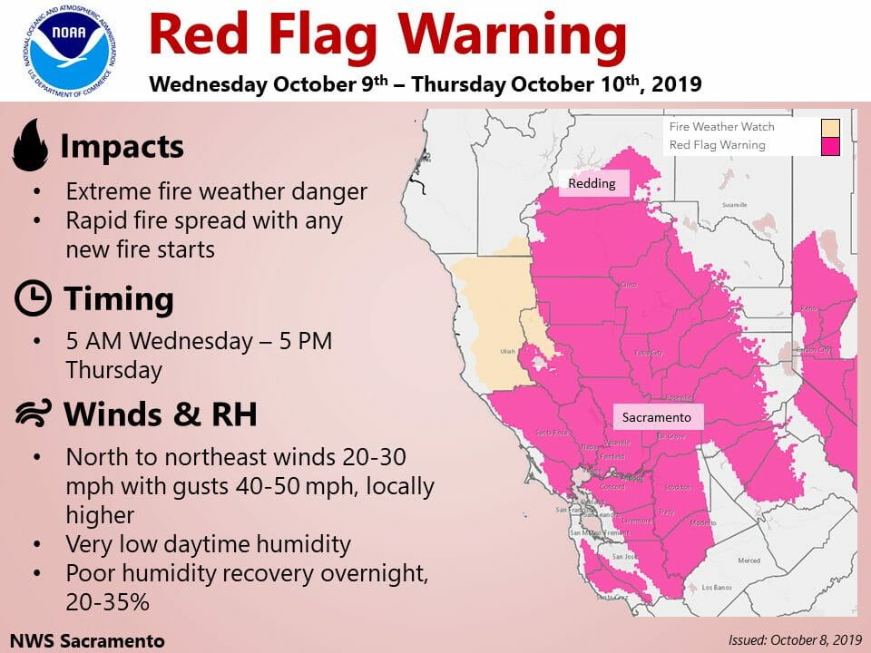
October 9, 2019 at 8:44 AM Red Flag Warning in effect, conditions overnight similar to Oct. 2017. Gusty northerly winds will be possible across interior NorCal into Thursday. There is the potential for gusts exceeding 40 mph in the Sacramento Valley and surrounding foothills and mountains.
October 9, 2019 at 8:34 AM Accident on Hwy 49 near Milhouse Drive, reported as a vehicle rollover, units en route.
October 9, 2019 at 8:00 AM NID’s Board of Directors meeting scheduled for 9:00 am in Lincoln has been canceled and will be rescheduled at a later date.
October 9, 2019 at 6:14 AM Firefighters have contained the extension to the wildland at 1/2 acre. Mop up operations beginning.
October 9, 2019 at 6:12 AM Firefighters at scene on Skylark are making good progress, Three engines and one water tender to continue in, all others can cancel.
October 9, 2019 at 6:04 AM First unit at scene on Skyland reports the structure on the ground. The fire has extended to approximately 1/2 to 1 acre of vegetation. All units to continue in.
October 9, 2019 at 5:51 AM Report of a barn on fire on Skyland Road on the San Juan Ris=she. Emergency services en route.
October 9, 2019 at 5:30 AM The power is off, but Camptonville School will be open today, Wednesday, October 9th. It is a scheduled minimum day. Bus service and food service are available! Nevada County school closures posted on the PSPS log.
October 8, 2019 at 10:13 PM Firefighters en route to a reported illegal burn pile on Scotts Flat Road, reported as a burn pile between two homes.
October 8, 2019 at 7:32 PM The Tahoe National Forest will NOT be conducting any Prescribed Fire activities starting tomorrow through Friday 10/11. This includes the eastside of the Tahoe NF which mostly lies outside of current Red Flag Warning areas
October 8, 2019 at 3:57 PM Accident on Tyler Foote Road near Hwy 49. Emergency services are on scene, Tyler Foote is blocked.
October 8, 2019 at 3:40 PM NWS update: Wind advisory now in effect from 8 pm Wednesday to noon Thursday.
TIMING: Wednesday into Thursday morning. Strongest winds are expected Wednesday night.
WINDS: Northeast winds 15 to 30 mph gusts up to 45 to 55 mph, locally higher over exposed ridges and near canyons.
October 8, 2019 at 3:37 PM The PSPS Edition – October 2019. This story will be updated with any new information regarding the Public Safety Power Shutoff (PSPS) event on October 9, 2019. The regular Happening Now log will continue to chronicle other events. You can find the latest PSPS outage map at the bottom of this page.
October 8, 2019 at 1:34 PM PG&E Will Proactively Turn Off Power for Safety to Nearly 800,000 Customers Across Northern and Central California.
October 8, 2019 at 11:54 AM As a reminder, various fire agencies are finishing up prescribed burns ahead of the Red Flag Warning. Smoke from these prescribed fires is noticeable in the lower elevations. There is no uncontrolled fire in the Nevada, Yuba, Placer and El Dorado areas at this time.
October 8, 2019 at 11:44 AM PG&E is sending the second wave of PSPS notifications out at this time. No firm time for the start of the event yet. Also:
We are currently experiencing high volume of traffic to our website & understand your frustration w/ the delay of accessing #PSPS related web pages. We apologize for the inconvenience and thank you for your patience as our team is working as quickly as possible to restore access. pic.twitter.com/9qTsDxbiNE
— PG&E (@PGE4Me) October 8, 2019
October 8, 2019 at 11:11 AM CAL FIRE Increases Staffing for Extreme Fire Danger Conditions. CAL FIRE firefighters are staffing up and preparing for the forecasted extreme fire weather across California. The National Weather Service has issued red flag warnings and fire weather watches for areas of northern, central and southern California. This will likely be the strongest offshore wind event so far this season.
October 8, 2019 at 9:31 AM The National Weather Service in Sacramento has issued a Red Flag Warning, which is in effect from 8 PM Wednesday to 5 PM PDT Thursday. The Fire Weather Watch is no longer in effect.
Affected Area: The Northern and North Central Sierra Nevada below 6000 feet and foothills.
Wind: North to northeast wind 15 to 25 mph with gusts 40 to 50 mph, locally higher in canyons and over exposed ridges.
Humidity: Daytime minimum humidities mainly in the teens with poor overnight recoveries of 25 to 35 percent Wednesday night.
Highest Threat: The Northern and North Central Sierra Nevada and foothills below 4000 feet.
A strong north to northeast wind event is likely across northern California early Wednesday morning continuing through Thursday. This will be the strongest wind event for the region this season. Dry conditions combined with the strong, gusty winds will bring extreme fire concerns to much of the area. The strongest Valley winds look to be early Wednesday through Wednesday evening, with the strongest winds over the foothills and higher terrain Wednesday evening into Thursday. Very low relative humidity values are expected each day, with poor overnight recoveries. Winds decrease Friday and dry weather continues through the weekend.
October 8, 2019 at 9:29 AM The tentative shutoff time is 4:00 am on Wednesday, according to the PG&E website.
October 8, 2019 at 7:51 AM Wind event starting early Wednesday into Thursday brings critical fire weather conditions. Gusty northerly winds will be possible across interior NorCal Wednesday into Thursday. There is the potential for gusts exceeding 40 mph in the Sacramento Valley and surrounding foothills and mountains.
October 8, 2019 at 1:02 AM Smoke from prescribed fires on the National Forests has settled over Nevada, Placer, Yuba and El Dorado counties. There are no uncontrolled fires at this time. The nightly inversion has pushed the particulate matter into the lower elevations.
October 7, 2019 at 8:44 PM Public Safety Power Shutoff Could Impact More Than 600,000 Customers Across Northern and Central California. If PG&E decides to implement a PSPS, the company expects to begin turning off power for safety early Wednesday morning. Based on the latest weather forecasts and models, PG&E anticipates the period of peak winds will occur from early Wednesday morning and last through Thursday midday.
October 7, 2019 at 7:58 PM The intermittent power outage for 796 customers the Peardale Chicago Park area has been partially resolved. Estimated time of full restoration is 8:45 pm.
October 7, 2019 at 3:47 PM NWS update: The main concern of the week will be the strong winds expected late Tuesday night into Thursday bringing critical fire weather conditions to much of the area. The aforementioned trough will dig into the Central Great Basin on Wednesday, increasing the north and east pressure gradients over NorCal. Valley winds will be strongest from the early morning to the evening on Wednesday with sustained winds as high as 30 mph at their peak. Gusts will range from 35-45 mph which may bring down some tree limbs and shift any unsecured outdoor belongings. Overnight on Wednesday, the strongest winds shift mainly to the foothill and mountain regions with gusts 40-45 mph, locally higher for wind prone peaks and areas exposed within northeast to easterly oriented canyons. All locations continue to see these stronger winds through Thursday afternoon as the pressure gradient weakens as the trough moves east.
October 7, 2019 at 2:49 PM PG&E has released preliminary maps of the Public Safety Power Shutoff (PSPS) event on Wednesday. The map may change but anyone in the affected zones should make a plan now. Zoom in on the map for greater details.

October 7, 2019 at 7:53 AM PG&E PSPS Watch update: Weather models continue to indicate potential for a widespread and strong offshore (Diablo) wind event Wednesday into Friday of this week with the main period of weather risk being Wednesday into Friday morning. Weather forecast models continue to show ample support for the event and have remained very consistent in forecasting the strongest event of the season so far and the strongest event since October 8th and 9th of 2017. The emergency operations center remains activated to prepare for a potentially widespread PSPS event. Fire Weather Watches remain in effect for the Sacramento Valley, elevated terrain adjacent to the valley, the northern Sierra Nevada, and the North/East Bay Hills. Predictive Services Northern Operations has issued a high risk’ forecast for the upcoming event. The PSPS potential forecast indicates a PSPS watch zones 1, 2, 3, 4, 5, 8 and elevated in zone 7 for Wednesday and Thursday. The PSPS potential forecast also indicates an Elevated potential in zones 3,4, 5 and 9 on Friday. P lease note that PSPS decisions are made at a more granular level; thus, only a portion of a zone may experience a PSPS event if warranted.
October 7, 2019 at 6:39 AM Gusty northerly winds possible across interior NorCal Wednesday into Thursday. A low pressure system digging into the Great Basin region will create gusty north to east winds over portions of interior Northern California Wednesday and Thursday. Daytime minimum relative humidities will be very low, mainly in the teens, with poor overnight recoveries Wednesday night. These will lead to critical fire weather conditions for the northern Coastal Range and foothills, the Sacramento Valley, and the Northern Sierra Nevada and foothills below 6000 feet.

October 6, 2019 at 9:45 PM PG&E has issued a PSPS WATCH for our area for Wednesday and Thursday due to significant winds forecasted this week. Looking ahead, the weather models continue to indicate potential for a widespread and strong offshore (“Diablo”) wind event Wednesday through Friday this week with the main period of weather risk Wednesday and Thursday. The PSPS potential forecast indicates elevated PSPS potential for zones 1,2, 3, 4, 5, 7 and 8 for this event. Please note that PSPS decisions are made at a more granular level; thus, only a portion of a zone may experience a PSPS event if warranted.
October 6, 2019 at 2:35 PM Loma IC is canceling the dozer and the water tender, the two crews to continue in for mop-up. Units at scene can handle.
October 6, 2019 at 2:30 PM Both the tanker and the air attack are returning to Grass Valley.
October 6, 2019 at 2:29 PM Air Attack reports 1/2 acre, burning at a slow rate of spread. Firefighters have a hoselay around the fire already.
October 6, 2019 at 2:27 PM Aircraft are en route to the fire, overhead in less than 2 minutes.
October 6, 2019 at 2:23 PM Incoming units to stage on Loma Rica Road.
October 6, 2019 at 2:22 PM Fire is becoming established in the grass, additional units are arriving n scene.
October 6, 2019 at 2:20 PM First unit at scene reports approximately 1 acre, held on one side by a creek.
October 6, 2019 at 2:17 PM Second report for the fire, estimating it at 1/4 acre. First unit at scene will be the Loma IC.
October 6, 2019 at 2:13 PM Full wildland dispatch for a reported fire on Loma Rica Road near Douglas Way, behind Pizza Round Up in Yuba County.
October 6, 2019 at 12:20 PM The National Weather Service in Sacramento has cancelled the Red Flag Warning. The stronger winds have decreased and will continue to decrease through the afternoon. Therefore the Red Flag Warning will be allowed to end early. However, localized wind prone areas will see gusty winds accompanied by low relative humidities until this evening.
October 6, 2019 at 10:34 AM Oregon Peak reports the column is no longer visible.
October 6, 2019 at 10:25 AM Smoke report from Oregon Peak, dissipating smoke about 5 miles out. Pike County lookout confirms the smoke.
October 6, 2019 at 9:51 AM PG&E is continuing line inspection flights with several helicopters today and in the coming days. One helicopter is currently over the McCourtney Road area, another one over North Auburn.

October 6, 2019 at 8:35 AM Power outage for 796 homes in the Peardale/Chicago Park area. Not related to a PSPS. PG&E is assessing the cause at the outage location, estimated time of restoration is 11:15 am.
October 5, 2019 at 8:37 PM PG&E Will Proactively Turn Off Power for Safety in Portions of Butte, Plumas and Yuba Counties on Saturday. PG&E expects to begin turning off power for approximately 10,000 customers at 10 p.m. tonight. Based on the latest weather readings, the company anticipates the period of peak winds will occur from 10 p.m. on Saturday, Oct. 5, through 8 a.m. on Sunday, Oct. 6.
October 5, 2019 at 8:36 PM Lanes are still blocked on Hwy 49 near the Independence Trail, extended closure for cleanup.
October 5, 2019 at 5:37 PM Still one-way traffic control on Hwy 49 near Independence Trail, roadway expected to be fully open in 10 minutes.
October 5, 2019 at 4:40 PM Accident on Hwy 49 near Independence Trail, large truck flipped on its side. The truck was carrying paint, which has spilled onto the roadway. No injuries reported. Expect delays.
October 5, 2019 at 10:28 AM Firefighters are en route for a smoke check in the area of Edwards Crossing.
October 5, 2019 at 10:10 AM Multiple accidents on Hwy 49 between Nevada City and Dorsey Drive, emergency services are on scene.
October 5, 2019 at 9:41 AM Winds will increase across the western Sacramento Valley and the northern Coastal mountains and foothills later today and tonight and persist into Sunday morning before decreasing. Strongest winds are expected this evening through early Sunday with local gusts up to 25-35 mph. A Red Flag Warning is in effect for this afternoon – Sunday afternoon. Daytime temperatures will also increase this weekend with Valley temperatures in the mid to upper 80s. Potential stronger northerly wind event starting early Wednesday ending early Thursday morning with gusts 30 to 45 mph over a larger area than this current event.
October 4, 2019 at 8:16 PM Pacific Gas and Electric Company (PG&E) today announced it may be proactively turning power off for safety and conducting a Public Safety Power Shutoff (PSPS) within the next 24 hours. To help reduce the risk of wildfire and keep our customers, their families and their homes and businesses safe, the company may be turning off power to approximately 12,026 customers in portions of Butte, Plumas and Yuba counties on Saturday.
The PG&E emergency operations center is now activated for a potential PSPS due to an offshore wind event expected to materialize over northern California Saturday night into Sunday morning. Weather forecast models have increased in strength over the past 24 hours and indicate breezy to locally gusty offshore flow will develop overnight Saturday night into Sunday across portions of the Northern Sierra and North Bay hills. The combination of dry fuels and locally gusty conditions has led the National Weather Service to issue a Red Flag Warnings for North Bay hills, above 1000’, and the Sacramento Valley and adjacent foothills Saturday night through Sunday morning. Predictive Services, Northern Operations, has also issued ‘High Risk’ designations for this event as well. Although the beginning of the event is now less than 48 hours away, models may continue to change and some uncertainty still exists. The updated PSPS potential forecast now indicates a PSPS Watch for northern areas of Zone 5 Saturday night into Sunday with the main period of risk occurring overnight into Sunday morning. Northern areas of zones 3 and 4 (portions of Napa, Lake, and Sonoma Counties) are now showing a PSPS Elevated state for Sunday. Elevated PSPS potential for zones 2, 3, 4 and 5 for a potential second event next week. Please note that PSPS decisions are made at a more granular level; thus, only a portion of a zone may experience a PSPS event if warranted.
October 4, 2019 at 4:08 PM Multi-car accident on the corner of Bell Road and Hwy 49 in Auburn. Emergency services are on scene and the westbound lanes are blocked. Traffic control is in place, but expect soem delays.
October 4, 2019 at 1:42 PM PG&E spokesperson on the likelihood of a Public Safety Power Shutoff event in Yuba, Nevada or Placer Counties: “At this time, the forecast doesn’t indicate the need to initiate a Public Safety Power Shutoff at this time, but weather conditions can change quickly. We remind our customers to have a plan and make sure we have your updated contact information.”

October 4, 2019 at 11:35 AM Northerly winds begin today across NorCal, though they will be relatively light with gusts mainly below 20 mph. Winds will increase across the western Sacramento Valley and the northern Coastal mountains and foothills Saturday and Sunday as conditions begin to dry. Strongest winds are expected Saturday evening through early Sunday with gusts up to 25-35 mph. A Red Flag Warning is in effect for Saturday afternoon – Sunday afternoon. Daytime temperatures will also increase this weekend with Valley temperatures in the mid to upper 80s.
October 4, 2019 at 11:31 AM Heads up. Due to very unsafe conditions access to the Independence East Trail is being closed by State Parks. The trailhead/bridge is no longer safe to use. More details to come.

October 4, 2019 at 11:11 AM The National Weather Service in Sacramento has issued a Red Flag Warning, which is in effect from 1 PM Saturday to 5 PM Sunday.
WIND: North to northeast wind 10 to 20 mph with gusts to 25 to 35 mph.
HUMIDITY: Poor overnight recoveries of 30 to 40 percent, locally lower, with daytime minimum humidities mainly in the teens.
HIGHEST THREAT: Over the west side of the Sacramento Valley and into the northern Coastal Range and eastern foothills, especially Saturday night into early Sunday, when winds will be strongest.
IMPACTS: any fires that develop will likely spread rapidly.
October 4, 2019 at 10:00 AM The active shooter drill at Brighton Greens has concluded.
October 4, 2019 at 8:13 AM The Deadwood underburn on the Tahoe National Forest is continuing today. Expect smoke to be visible from I-80. Foresthill, Baker Ranch and Michigan Bluff could also see smoke from the 1,200-acre project. Daily ignitions of approx. 20-100 acres at a time. bit.ly/2AJPHc6
October 4, 2019 at 8:11 AM A reminder: Active Shooter Preparedness Exercise at Brighton Greens Office Friday Morning
October 4, 2019 at 7:35 AM Mild weekend ahead with at times breezy north winds. High pressure over the west coast will bring fair skies and warm temperatures over the weekend. Saturday will see highs near normal with northerly breezes. Sunday will see lighter winds and slightly above normal temperatures.
October 3, 2019 at 1:22 PM The helicopter in the La Barr Meadows/Hwy 49 area is flying PG&E lines for their vegetation management program. Several helicopters continue the line inspections and will do so in the next few days.
October 3, 2019 at 8:59 AM Power outage affecting 34 homes on Starduster Drive off Bitney Springs Road. PG&E is assessing the cause at the outage location. Estimated time of restoration is noon.
October 3, 2019 at 7:14 AM A little cooler today, then warming through the weekend. A weak weather system passing to the north will bring a little cooling today. High pressure building in behind this system will bring warming Friday and through the weekend.
October 2, 2019 at 10:06 PM Driver is out of the vehicle, no need for extrication. CAL FIRE units are being canceled.
October 2, 2019 at 10:00 PM Vehicle accident, extrication required, on northbound Hwy 49 at the Brunswick ramp. Numerous units en route, CHP reporting solo vehicle accident, car vs tree.
October 2, 2019 at 3:14 PM PG&E Helicopter (marked “Fire” on its belly) is continuing line inspections in Nevada County today and will so in the next few days.
October 2, 2019 at 2:33 PM Firefighters have contained the small fire on Chalk Bluff, mop-up is ongoing. Units will be released in approximately 30 minutes.
October 2, 2019 at 8:49 AM NorthOps outlook calls for warmer and drier than normal conditions through January. Climatologically speaking, most regions have exited fire season for the year. However, the Southeast and California are known to have bimodal fire seasons, meaning fire activity can have two peak periods. For California, the first peak arrives during the summer months and is followed by a brief lull. A second peak arrives during the October through December period with the arrival of Foehn Winds (Santa Ana, Diablo, Sundowner, and North Winds.)
October 2, 2019 at 7:31 AM Warm-up continues, no precip in the forecast for the next seven days. Temperatures will be slightly warmer across interior NorCal today.
October 1, 2019 at 10:47 AM Firefighters are requesting a prevention officer, and a Sheriff’s deputy to respond to the reported smoke off Brunswick Road, with a Fish&Wildlife officer if possible.
October 1, 2019 at 10:40 AM Firefighters have located the smoke in the Brunswick area, appears to be a small campfire. Units are making their way in to the location.
October 1, 2019 at 10:29 AM Smoke check in the Ophir Hill area, Brunswick near East Bennett, units en route.
October 1, 2019 at 10:10 AM PG&E Helicopter (marked “Fire” on its belly) is continuing line inspections in Nevada County today. Currently over Round Mountain and Lake Vera areas.
October 1, 2019 at 9:34 AM Prescribed underburns and pile burns planned today:
Sagehen – pile burning
Calpine – hand piles
Butcher Ranch – hand piles
Little Grass Valley Reservoir – underburn
All these prescribed fires are fully staffed and firefighters monitor them until completed. There is no need to report smoke from these fires.
October 1, 2019 at 9:02 AM Units en route to a reported accident (heard only) in Alta Sierra on Ball Road at Francise Drive.
October 1, 2019 at 8:55 AM Possible big rig fire near the I-80/Hwy 20 split. Reported as smoke only, units en route.
October 1, 2019 at 6:37 AM Milder temperatures are forecast for the remainder of the week. Highs will be around 5 to 10 degrees warmer today compared to Monday’s, but will still be well below average for early October.
October 1, 2019 at 6:00 AM Last month’s log is available here.