Happening Now is a feature designed to bring updates, announcements and info on news items throughout the day. You are invited to participate. See a road closure? A business opening? A smoke plume? Storm-related mishaps like downed trees, power lines, road or other flooding? Email us at news@yubanet.com or call 530-478-9600 to let us know. You can also text us reports at 530-409-9888, but please don’t text or call while driving. Thanks!
January 31, 2017 at 10:00 PM Caltrans is alerting motorists that rock scaling operations will require daytime lane closures on Highway 49 between Newtown Road and Tyler Foote/Birchville Road north of Nevada City from 7 a.m. to 5 p.m. January 31 through February 28, 2017.
January 31, 2017 at 4:22 PM Bell Road in Auburn is closed between Bell and Richards. No estimate of reopening. Thanks to reader Jean for the heads up.
January 31, 2017 at 2:23 PM A silver Toyota missed the Brunswick on ramp to Hwy 49 and ended up on the CVS property in the Brunswick Basin. Emergency services are clearing the scene now.
January 31, 2017 at 9:11 AM Vehicle in the ditch on Lime Kiln Road, a quarter mile past Duggans Road in Grass Valley. Driver is out of the vehicle, emergency services en route.
January 31, 2017 at 7:18 AM Hwy 20 north of Nevada City from Coyote Street to Scotts Flat Road has a lane closure for tree work until 5:30 pm today.
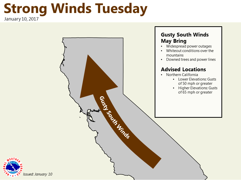
January 31, 2017 at 7:11 AM Wet, windy and snowy weather ahead. A storm system this week will bring rain and mountain snow to northern California. Light precipitation will start Wednesday evening across the Coastal and southern Cascade mountains and become more widespread across the area after midnight. Heavier precipitation amounts are expected midday Thursday through Friday with scattered rain and snow showers remaining Saturday as the system exits the region. Storm total snow could reach 1 to 3 feet at pass levels, causing travel difficulties. Gusty winds are probable Thursday into Friday, strongest Thursday afternoon and again later Friday morning. These winds are not expected to be as strong as with recent storms.
January 30, 2017 at 10:29 AM Good news from Nevada County Public Works: After 4+ days of 12-hour work in (mostly) agreeable conditions, Maybert Road is now open to traffic. Road crews may be on site today to complete final work and cleanup of the site, causing intermittent delays. County staff will continue to monitor the road throughout the winter to ensure future storms don’t affect the repairs.
January 30, 2017 at 8:50 AM The #2 lane of southbound Hwy 49 is closed at Coyote Street in Nevada City for ongoing work. Estimated time of reopening is 3:00 pm.
January 30, 2017 at 7:17 AM Winter storm with gusty winds late Wednesday through Friday. A storm system mid to late-week will bring rain and mountain snow to northern California. Light precipitation will start Wednesday night and become more widespread across the area Thursday. Heavier precipitation amounts are expected Thursday through Friday before tapering off by early Saturday. Storm total snow could reach up to 2 feet at pass levels, causing travel difficulties. Gusty winds are possible Thursday, which could bring down tree branches and cause localized power outages.
January 28, 2017 at 11:06 AM Dry and sunny with a chance of headache. High pressure ridge will bring dry weather and near to above normal temperatures continuing over the next several days. Patchy fog is possible again in the mornings in the valley and could be dense in some spots.
January 28, 2017 at 9:15 AM Latest update for the remaining 75 customers out of power along Joerschke Drive: Estimated restoration time is 2:30 pm.

January 28, 2017 at 8:01 AM Grass Valley PD posted the full explanation of the Brunswick power outage: At about 6:00am Officers responded to a vehicle accident on Joerschke Drive. A vehicle failed to negotiate a turn and rolled into a power pole which sent a surge to the PG&E hub on Sutton Way. That surge knocked out power to a great deal of homes and dozens of businesses. The driver fled the scene and a passenger was transported to the ER for evaluation.
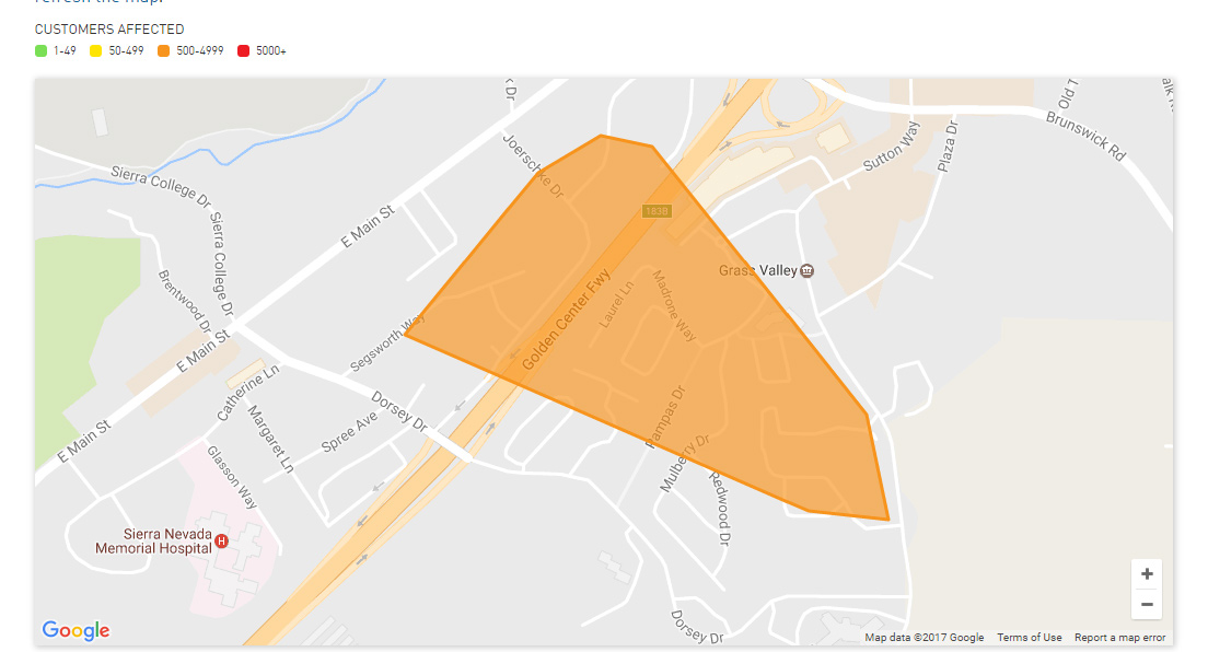
January 28, 2017 at 7:52 AM Outage near Sutton has been reduced to 533 homes and businesses. Estimated full restoration time is 9:15 am.
January 28, 2017 at 7:38 AM Crews are also on site at a power outage affecting 227 customers along Indian Springs Road between McCourtney Road and Spenceville Road between Grass Valley and Penn Valley.
January 28, 2017 at 7:26 AM Power is being restored to customers affected by the early-morning outage. Circuits are being re-energized, outage zone is reducing.

January 28, 2017 at 7:01 AM Power outage affecting 2,522 customers, PG&E assessment crew is en route to the outage. A vehicle vs a power pole on Dorsey Drive is a likely cause.
January 27, 2017 at 6:07 PM Public’s help sought to locate owner of suspect vehicle near robbed Tri Counties Bank. The vehicle is confirmed to be a Toyota “Tacoma” TRD pick-up truck with oversized tires and black rims.
January 27, 2017 at 2:23 PM George Jung, aka Boston George, spent almost 20 years in federal prison for cocaine trafficking and was released in 2014. He was arrested for an alleged parole violation in December 2016. Jung, portrayed by actor Johnny Depp in the 2001 movie “Blow,” is currently housed at Wayne Brown Correctional in Nevada County, under a federal government contract. Jung is now 76 years old and declined an interview.
January 27, 2017 at 2:16 PM Good advice from the Building Department on how to deal with snow and ice on buildings.
January 27, 2017 at 1:27 PM Three-vehicle collision on Hwy 20 near Lake Spaulding Road. Emergency services on scene, no injuries reported.

January 27, 2017 at 12:50 PM Caltrans: Highway 89 over Emerald Bay to remain closed thru weekend. Lot of work left and equipment in for repairs.
January 27, 2017 at 10:15 AM A big rig is stalled on northbound Hwy 49 just south of the McKnight off ramp in Grass Valley. Use caution in the area.
January 27, 2017 at 9:58 AM Solo vehicle rollover on Hwy 49 near Downieville.
January 27, 2017 at 8:46 AM NCSO confirmed that two juvenile girls attempted to hang themselves yesterday evening in Western Gateway Park. The attempt was unsuccessful and the two patients were taken to Rideout Hospital. No further details will be released.
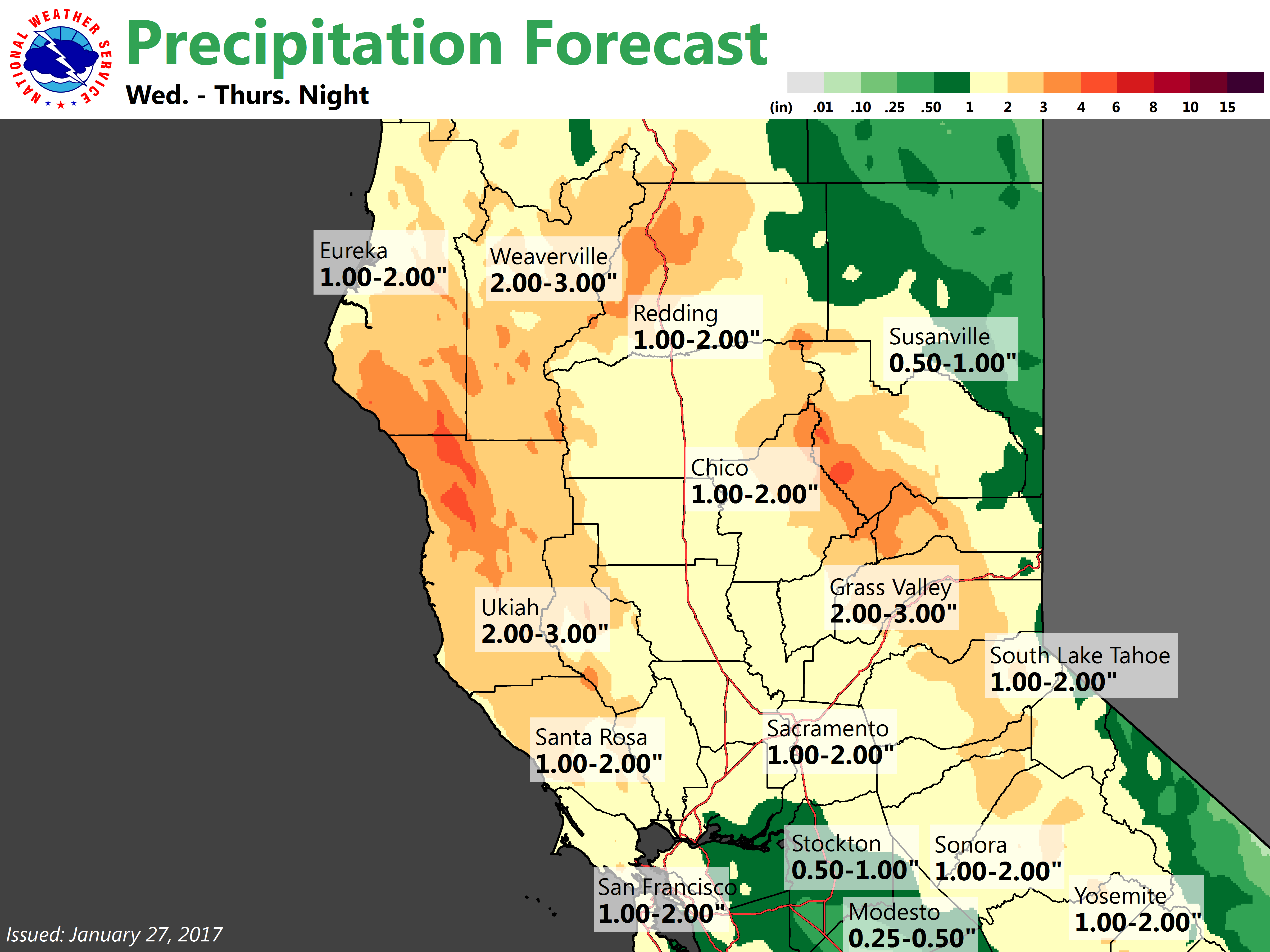
January 27, 2017 at 8:24 AM Get ready. An approaching storm system next week will bring increased chances for rain and snow to northern California. Scattered precipitation will start Tuesday night across the mountains and become more widespread into Wednesday through Thursday. Rain and snow is expected to continue through Friday.
January 27, 2017 at 8:17 AM Construction work continues on Hwy 49 at the 49/20 split near Coyote Street in Nevada City. Guardrails will be repaired at the Hwy 49 Colfax exit. Expect delays at the Idaho-Maryland roundabout. Additional work near the Empire exit (near the sinkhole) on Hwy 49. Give yourself some extra time.
January 27, 2017 at 8:00 AM A weekend to get outdoors and soak up the sun. High pressure over the west coast will bring fair skies over the coming weekend. Some morning fog will be possible in the valley each day but light north winds will likely keep it at a minimum. Enjoy the nice weather this weekend. The next chance of widespread precipitation will start next Tuesday night with precipitation lasting through the end of the week.
January 27, 2017 at 7:53 AM Vehicle rollover accident on Lime Kiln Road near Duggans Road south of Grass Valley. Emergency services en route.
January 26, 2017 at 6:14 PM Two patients were transported to an area hospital after an alleged hanging attempt in Western Gateway Park in Penn Valley. The condition and identity of the patients is unknown. Numerous emergency services and law enforcement are on scene.
January 26, 2017 at 6:07 PM Accident on southbound Hwy 49 and Upward Way, south of Grass Valley near Christian Life. The southbound lane is blocked and traffic is backed up to McKnight, use an alternate route if possible.
January 26, 2017 at 3:25 PM NCSO has released the lockdown for Union Hill. The buses will be 10-15 minutes late. Students can now be picked up.
January 26, 2017 at 3:16 PM Union Hill is currently on lockdown. Buses will be late and students are not being able to be picked up. Everyone is safe, parents have been notified.
January 26, 2017 at 11:16 AM Correction from NCSO: Tri Counties Bank in Lake of the Pines was robbed. Suspect is wearing black mask, green cammo jacket and dark pants. No weapons seen. No vehicle description.
January 26, 2017 at 11:06 AM Per a student at BRHS: School is in shelter in place mode. Lights are still on and classes continue.
January 26, 2017 at 11:04 AM Per NCSO: Bank robbery at Great Western Saving in Lake of the Pines. No suspects yet.
January 26, 2017 at 11:01 AM Magnolia and Cottage Hill Schools also on lockdown after the reported bank robbery on Combie.
January 26, 2017 at 10:47 AM Bear River High School is in lockdown after a reported bank robbery on Combie Road. All students are safe.
January 26, 2017 at 9:24 AM Accident on the 13400 block of Ridge Road in front of A to Z Supply in Grass Valley, the roadway is clear.
January 26, 2017 at 7:52 AM Overcast and chilly today. A weak weather system dropping southward through Norcal will bring a slight chance over showers today over the northern mountains and Sierra. Only light precipitation is expected. Otherwise, partly cloudy skies are forecast for today with near to below normal daytime highs
January 25, 2017 at 6:00 PM NID isolates water supply as Deer Creek in Nevada City runs milky. NID has taken precautions, the drinking water supply is not affected.
January 25, 2017 at 4:06 PM Video footage of the 7ft culvert underneath Hwy 49 near Freeman lane shows good news. No apparent damage to the culvert found, the freeway is fully reopening soon.
January 25, 2017 at 11:59 AM Vehicle vs telephone pole, pole is down on the 10000 block of Willow Valley Road in Nevada City.
January 25, 2017 at 9:50 AM #2 lane closed on SB Highway 49 between Empire St. and McKnight Way in Grass Valley for maintenance work. No ETO.
January 25, 2017 at 7:01 AM Dry with early morning frost and fog. A weak wave skirts the northern forecast area late today into Thursday followed by weekend fog across southern Sacramento and northern San Joaquin Valley. The next significant cold, wet frontal system impacts the region next Tuesday or Wednesday.
January 24, 2017 at 3:17 PM Accident on Hwy 174 at Live Oak Lane. Units on scene can handle.
January 24, 2017 at 9:44 AM Brunswick Road is open again. Use caution, the roadway is still icy.
January 24, 2017 at 9:43 AM Rollover accident on Red Dog Road at Caledonia Way. Emergency services en route.
January 24, 2017 at 8:54 AM Brunswick Road between the Cedar Ridge Y and Greenhorn Road is closed due to numerous spin-outs.
January 24, 2017 at 8:52 AM Accident on Banner Quaker Hill Road outside of Nevada City. The road is extremely icy.
January 24, 2017 at 8:17 AM Single car accident on Hwy 174 at North Meadow View Drive. Emergency services on scene, no injuries reported.
January 24, 2017 at 6:59 AM Drier weather and freezing overnight temps on tap. Clearing skies, light winds and a lingering cold air mass will result in chilly temperatures across the interior of NorCal tonight. Widespread frost will be possible through the Central Valley and foothills.
January 23, 2017 at 4:38 PM Caltrans and CHP are on scene of the sinkhole on Freeman Lane in Grass Valley. At this point, no sinkhole has developed on the freeway, only a slight dip can be felt in the slow lane. Caltrans engineers have set markers inside the drain to monitor for any additional sinkage. The area has been continuously monitored since the sinkhole developed 2 weeks ago. Do not stop on the freeway!
January 23, 2017 at 3:23 PM The #2 lane has been reopened on Hwy 49 near McKnight, but the shoulder remains closed.
January 23, 2017 at 3:17 PM The #2 lane on southbound Hwy 49 at McKnight Way is being shut down due to a developing sinkhole.
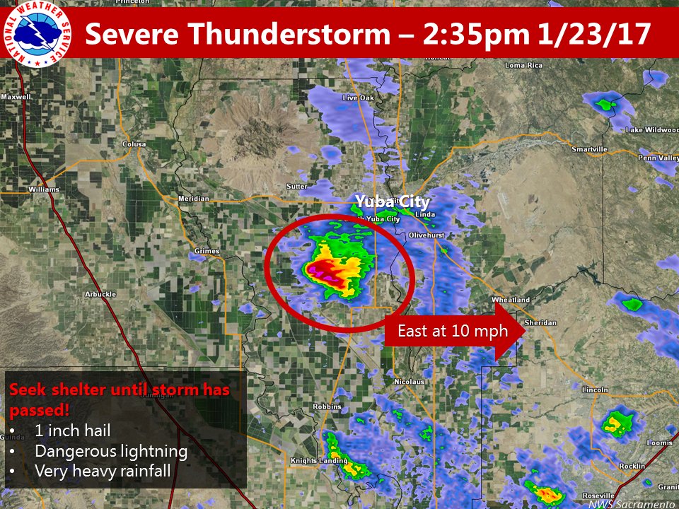
January 23, 2017 at 2:40 PM Severe thunderstorm located near Tisdale. Seek shelter from hail & lightning until storm has passed!
The National Weather Service in Sacramento has issued a Severe Thunderstorm Warning for Central Sutter County and Southwestern Yuba County until 3:30 PM.
At 2:34 PM, Doppler radar indicated a severe thunderstorm capable of producing abundant quarter size hail. This storm was located near Tisdale, or 8 miles southwest of Marysville, and moving east at 10 mph. Locations impacted include: Marysville, Yuba City, Tudor, Olivehurst, Arboga, South Yuba City, Linda, Wheatland and Tierra Buena.
January 23, 2017 at 1:38 PM Caltrans: Highway 89 from Squaw Valley to Tahoe City was opened back up to traffic at 11 a.m. this morning. Avalanche control went much smoother than anticipated and did not slide any snow onto the roadway.
January 23, 2017 at 1:32 PM The Nevada County Camera Club Meeting is cancelled for tonight due to snowy/winter weather. It is rescheduled for next Monday, Jan 30th – same time – same speaker. Jerry Berry will be giving his presentation “Using Smoke to Create Images Reflective of Asian Brush Painting”. The meeting will begin at the same time, 6:15 pm and will be held in the usual location, Unity in the Gold Spiritual Center, 180 Cambridge Court, Grass Valley.

January 23, 2017 at 12:37 PM 363 customers still affected by a power outage from another downed power line in the You Bet area. PG&E repair crew is on-site working to restore power, estimated restoration time is 6:30 pm tonight.
January 23, 2017 at 11:23 AM A big rig is blocking the #2 lane just south of the Golf FLat off ramp on Hwy 49 near Nevada City.
January 23, 2017 at 11:19 AM Power outage in Chicago Park has been fully resolved.
January 23, 2017 at 10:15 AM A large tree is blocking Hwy 20 just east of the overlook in Bear Valley before the junction with I-80.

January 23, 2017 at 9:50 AM Forest Park Lane off Hwy 174 in Peardale is closed due to downed power lines.
Crews are on site, replacing poles and repairing the lines. The outage has been reduced to 363 PG&E customers. Thanks again to Philip Mally for the photo.

January 23, 2017 at 9:38 AM You Bet Road is still closed, but should reopen within the hour. Thanks to reader Philip Mally for the photo. Avoid coming down You Bet, there is no space to turn around.
January 23, 2017 at 9:35 AM Power outage for Foresthill to Michigan Bluff is affecting 592 homes. PG&E crews in the area.
January 23, 2017 at 9:28 AM Power lines down and transformer on the ground at Main Street and Drum Forebay Road in Colfax. Emergency services en route.
January 23, 2017 at 9:21 AM Power outage along Hwy 174 has been reduced, You Bet at Pearson Road is still blocked, crews are working to reopen the road.
January 23, 2017 at 8:30 AM Camptonville Elementary will not have a late start. School is closed today due to a power outage in the area.

January 23, 2017 at 8:23 AM A tree is blocking the roadway on You Bet Road and Pearson Road. The tree is in the power lines, Nevada County Public Works on scene and waiting for PG&E crews to repair the damaged lines. 1,006 customers affected now.
January 23, 2017 at 8:12 AM 430 homes in the Camptonville area have lost power. Outage extends from Pike to the Willow Creek Campground. No estimated time of restoration yet.
January 23, 2017 at 8:07 AM Power outage along Hwy 174 in Peardale has extended. PG&E crews have found downed power lines and are repairing them.
January 23, 2017 at 7:25 AM The snow is starting to stick in Alta Sierra, according to a reader report. Use extreme caution if you are driving on Hwy 49 or 20, reduce your speed and turn on your headlights (Yes, that seems to be an issue)
January 23, 2017 at 6:51 AM Bitney College Prep School is canceling school for today.
January 23, 2017 at 6:45 AM The power outage in North Columbia includes Grizzly Hill School. No school today, according to reader Scott.
January 23, 2017 at 6:44 AM Power outage affecting 42 customers in North Columbia on the San Juan Ridge. PG&E is unable to access the affected equipment.
January 23, 2017 at 6:32 AM 50 homes on Dalmatian Drive and Tahoe View Drive off Hwy 174 past You Bet Rd are without power.
January 23, 2017 at 6:30 AM Field personnel have found a downed power line on Brookview Drive Circle between Rattlesnake Road and Peardale. Repair crew en route to restore power to 40 homes.
January 23, 2017 at 6:21 AM Rain and snow showers today, drier weather starting Tuesday. Scattered showers and a few thunderstorms will continue across the region today. Lighter snowfall accumulations are expected across the NorCal foothills and mountains through Tuesday morning. Snow levels around 2000-3000 feet.

January 23, 2017 at 6:16 AM Per Placer County: An avalanche in Tahoe North between Tahoe City and Alpine Meadows Rd has closed Hwy 89.
January 23, 2017 at 6:00 AM Camptonville Elementary School will have a late start today. Classes will begin at 10:25 am.
January 22, 2017 at 8:25 PM Snow in western Nevada County below 3,000 ft should taper off within the next hour. If you can delay being on the road, do it.
January 22, 2017 at 8:17 PM Accident on Gracie And Banner Lava Cap in Nevada City.
January 22, 2017 at 8:12 PM Brunswick Road in Grass Valley is closed temporarily due to snow and vehicles stuck on the incline.
January 22, 2017 at 7:44 PM Non-injury accident, car vs snow plow on Noel Lane and Hwy 174 at the Cedar Ridge Y.
January 22, 2017 at 7:41 PM Car slid of the road between Sontag Hill and Capitol Hill on You Bet in Grass Valley.
January 22, 2017 at 7:06 PM Non-injury accident on Brunswick Road at Wood Rose Way in Grass Valley.
January 22, 2017 at 6:06 PM Spin outs reported on county roads. Slow down, snow is starting to snarl traffic.
January 22, 2017 at 5:36 PM 545 customers still out between Mooney Flat and Indian Springs Road in the Penn Valley/Smartsville area. Lightning in the area caused outages, PG&E repair crews are on scene, they have restored power to over 3,400 homes already.
January 22, 2017 at 5:00 PM Power has been restored to most homes in Penn Valley.
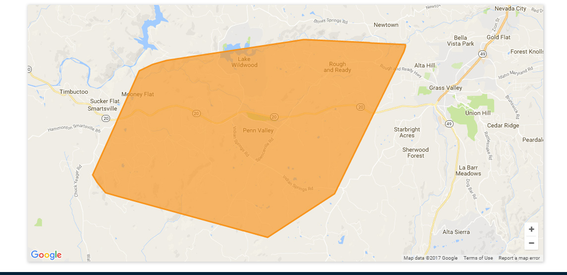
January 22, 2017 at 3:39 PM Power outage in the Penn Valley area affecting 3,996 homes. PG&E has assigned a crew to assess the outage. Could be related to the power lines down on Red Lane.
January 22, 2017 at 3:32 PM Report of thundercell now over Smartsville, heavy hail reported and power outage.
January 22, 2017 at 3:30 PM Report of power lines arcing on Hwy 20 just east of Red Lane. Penn Valley Fire en route.

January 22, 2017 at 2:28 PM NWS Sacramento: At 2:24 PM PST, Doppler radar was tracking a strong thunderstorm near Sheridan, or 11 miles northwest of Rocklin, moving northeast at 40 mph.
Half inch hail and winds in excess of 30 mph will be possible with this storm.
Locations impacted include: Grass Valley, Lincoln, Lake Of The Pines, Lake Wildwood, Colfax, Sheridan, Rough And Ready, Alta Sierra, Beale AFB, North Auburn, Wheatland, Penn Valley, Meadow Vista and Higgins Corner.
Precautionary/Preparedness Actions
Heavy rainfall is also occurring with this storm, and may lead to localized flooding. Do not drive your vehicle through flooded roadways.

January 22, 2017 at 1:30 PM The full account of the earlier reported structure fire on Vee Court.
January 22, 2017 at 1:04 PM Non-injury accident, two vehicles, on northbound Hwy 49 at Ladybird Drive. All vehicles and emergency services are on the right-hand side of the road. Use caution in the area.

January 22, 2017 at 12:09 PM The store at Soda Springs is open! Thanks to reader Delia for sending the picture. She says, “Now that’s a lot of snow. They do a great community service by being open. Thank You Cheryl and Tony Padrino.”
January 22, 2017 at 10:46 AM Heavenly ski resort is closing for the day due to high winds & heavy snow. Buses will stop running at 12 due to travel difficulties.
January 22, 2017 at 10:13 AM Structure fire on Vee Court, off North Bloomfield Road outside of Nevada City, in the early morning hours. The structure, described as a log cabin, was fully involved, with flames through the roof when the first units arrived on scene. Most units have been released, overhaul and mop up are done. Prevention officer still on scene.
January 22, 2017 at 10:04 AM Caltrans: I-80 will re-open at 10 am Chain control will be Truckee to Drum, trucks maximum, no single drives, no double trailers. Single file.
January 22, 2017 at 9:29 AM Per CHP Truckee: I-80 is CLOSED, westbound at the Nevada State Line and eastbound in Colfax.
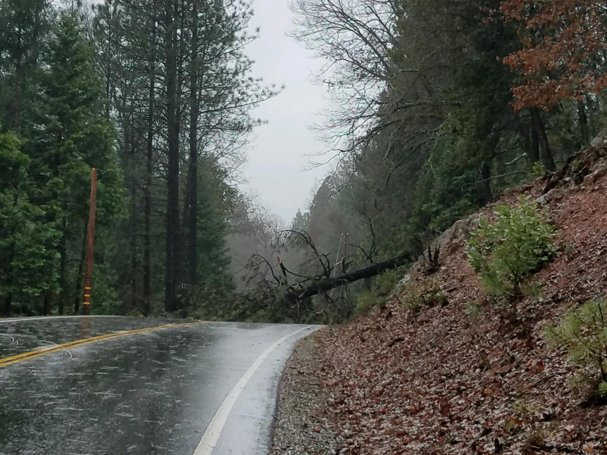
January 22, 2017 at 9:04 AM Report of a large Pine tree across the roadway on Tyler Foote approximately 1 mile from Jackass Flats Road on the San Juan Ridge.
January 22, 2017 at 9:01 AM Rain, wind and possible low snow continue into Monday. Strong gusty winds will gradually decrease this morning. Rain and snow continue into early Tuesday morning, but the brunt of precipitation will be Sunday into Monday. Check CalTrans road conditions prior to mountain travel. Isolated thunderstorms, with small hail possible, could develop this afternoon and Monday afternoon. Heavy snow will continue over the NorCal mountains into early Monday, then a few showers will linger into Tuesday.
January 22, 2017 at 8:50 AM Sierra Roots is opening the cold weather shelter at Seaman’s Lodge in Nevada City on Sunday night, Monday night and Tuesday night. The shelter will open at 6:30 pm.
January 22, 2017 at 8:37 AM 190 homes along Hwy 20 east of Nevada City from Cooper Road to the White Cloud Forest Service station are out of power. Downed trees on power lines. No estimated time of restoration.
January 22, 2017 at 8:35 AM In Nevada County Hwy 20 is closed east bound from post mile 17.83 on Nevada Street in Nevada City and west bound from post mile 45.55 the junction of I-80 due to downed trees. No estimated time of opening. No detour available at this time.
January 22, 2017 at 3:21 AM Power outage along Hwy 20 from Conservation Road to White Cloud. PG&E has assigned a crew to assess the outage.
January 22, 2017 at 3:20 AM Power outage affecting 111 customers in the Alleghany and Plumbago areas up to Downieville. PG&E is unable to access the affected equipment, no estimated time of restoration.
January 22, 2017 at 2:48 AM Starting at the end of the freeway in Nevada City, chains or traction devices are required on all vehicles except four wheel / all wheel drive vehicles with snow tread tires on all wheels in Hwy 20.
January 21, 2017 at 8:53 PM Caltrans: Northbound 49 Full Closure from Yuba County Line to Brandy City Rd due to Slide Removal. Expected to end at 12:01pm Jan 24, 2017
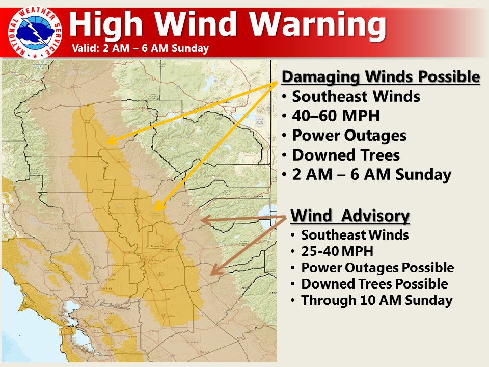
January 21, 2017 at 8:40 PM The National Weather Service in Sacramento has issued a high wind warning, which is in effect from 2 am to 6 am Sunday. A wind advisory has also been issued. This wind advisory is in effect from 6 am to 10 am Sunday.
Timing: Southerly winds increase late tonight with strongest winds expected early Sunday morning. Winds decrease by Sunday afternoon but remain breezy into Sunday evening.
Winds: Southerly winds 25 to 40 mph with gusts 50 to 60 mph. A brief period of damaging winds possible after midnight until early Sunday morning with sustained wind speeds of at least 40 mph or gusts of 60 mph or higher.
January 21, 2017 at 9:52 AM Chain control is set up on Hwy 20 at the 5 Mile House east of Nevada City for all vehicles attempting to get to I-80. Be patient, be prepared.
January 21, 2017 at 9:34 AM Scattered showers expected today with possible isolated afternoon thunderstorms. Next strong Pacific storm brings widespread precipitation to Interior Northern California tonight into Sunday turning showery later Sunday through early Tuesday. System expected to produce around 1 to 2 inches of rain in the Central Valley with heavy snow in the mountains above 3000 feet. Hazardous mountain travel likely with chain controls, delays, accidents, and white-out conditions at times. Strong winds will develop tonight and persist through Sunday morning with possible downed trees and power outages. Isolated thunderstorms which may produce small hail will be possible today through Monday, especially in the afternoon. Localized flooding remains a concern, especially near area creeks, streams, and rivers. Decreasing showers expected later Monday into early Tuesday, then dry weather forecast through the remainder of the week. Winter Storm Warning until 4 am Monday, Wind Advisory from 10 pm this evening to 10 am Sunday.

January 20, 2017 at 4:41 PM Tree down across Hwy 20, earlier this afternoon. Photo courtesy Kyla Kyla Halford.
January 20, 2017 at 4:40 PM Report of a tree leaning into the roadway on Hwy 49, 150 yards from the South Yuba Bridge.
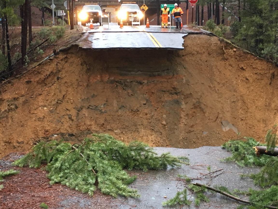
January 20, 2017 at 3:37 PM Maybert Road in Washington repair update from Public Works: Pending weather or other factors that could delay repair work, road crews will be out next Tuesday or Wednesday to begin repairs on the road. County crews will be taking a similar approach to the Maybert repairs completed in 1997 – the last time the Yuba River washed out this portion of Maybert Road. This approach includes the use of nearby native boulders and rock on adjacent properties to rebuild the road to a similar condition prior to the recent storms. The County has also rented heavy excavation equipment capable to arrive at the site mid-week to supplement existing county crews and equipment. With the heavy damage throughout the county on northern California, we were fortunate to find available this equipment so quickly. The work is expected to take a week or so to complete. Weather permitting, we’re targeting February 3rd (or sooner) to reopen to road to traffic. If the weather refuses to cooperate and delays construction, or if site conditions affect the ability to road crews to safety complete repair work, I will follow up with this group accordingly and revise the schedule. For additional updates on the project schedule and other road work, please visit our Facebook page at www.facebook.com/nevcopwsocial.
January 20, 2017 at 2:00 PM Tow truck on scene now at the Bennett Street off ramp on Hwy 49, use caution in the area. One vehicle was blocking all lanes to Hwy 174.
January 20, 2017 at 1:45 PM Based upon the National Weather Service’s high reliability of a forecasted widespread significant snow event for Sunday and Monday, the Lake Tahoe Basin Management Unit offices in South Lake Tahoe will be closed Monday, January 23rd. Safety of the public and our employees is the most important factor in our decision to temporarily close an office. We appreciate the extra precautions visitors will make in planning for their trip to the Basin and during recreation on the forest.
January 20, 2017 at 12:53 PM Watch for tree debris in the roadway on Hwy 174 near Meadow Drive in the Peardale area.
January 20, 2017 at 9:20 AM Electrical hazard over I80 eastbound at Baxter, power lines are over the roadway. Emergency services on scene.
January 20, 2017 at 8:57 AM The NWS Sacramento has extended the wind advisory until 1 pm today.
January 20, 2017 at 8:22 AM Gold Country Stage transit reports all routes are running today.
January 20, 2017 at 8:06 AM Non-injury accident on westbound Hwy 20 near Penn Valley Drive.
January 20, 2017 at 7:54 AM As of right now, Hwy 49 between Nevada City and North San Juan is open. Hwy 49 is closed between Camptonville and Downieville due to a slide.
January 20, 2017 at 7:19 AM Hwy 20 from Nevada City to the junction of I80 is closed to all big rigs. Chains or traction devices are required on all vehicles except four wheel / all wheel drive vehicles with snow tires on all wheels.
January 20, 2017 at 7:09 AM Wet, windy and snowy – through Tuesday. The next system impacts NorCal today through Saturday with another system for Sunday through early Tuesday. Hazardous mountain travel likely with chain controls, delays, accidents, and white-out conditions at times. Gusty winds will accompany each system with the likelihood of additional power outages and wind damage. Localized flooding remains a concern, especially near area creeks, streams, and rivers. It does look like a dry period after Tuesday through at least the end of next week!
January 20, 2017 at 7:02 AM Caltrans: Slides continue on Hwy 49 – Closed from Sierra County line to Indian Valley. No detour, No ETO.
January 20, 2017 at 6:50 AM Per Placer County Office of Education: Both Alta Dutch Flat and Tahoe Truckee School Districts are closed today due to snow.
January 20, 2017 at 6:48 AM Durham School Buses are running normally, at this time, in Nevada County.
January 20, 2017 at 6:46 AM Hwy 49 is closed in all directions due to a rock and mudslide at Brandy City Road near Camptonville.
January 20, 2017 at 6:43 AM Numerous reports of spinouts on county roads. Car stuck on Red Dog Road. Big rig stuck on Loma Rica Drive near the Nevada County Airport.
January 20, 2017 at 6:37 AM Gold Country Lift will not be providing services today due to snow.
January 19, 2017 at 7:55 PM Latest update from the NWS Sacramento:
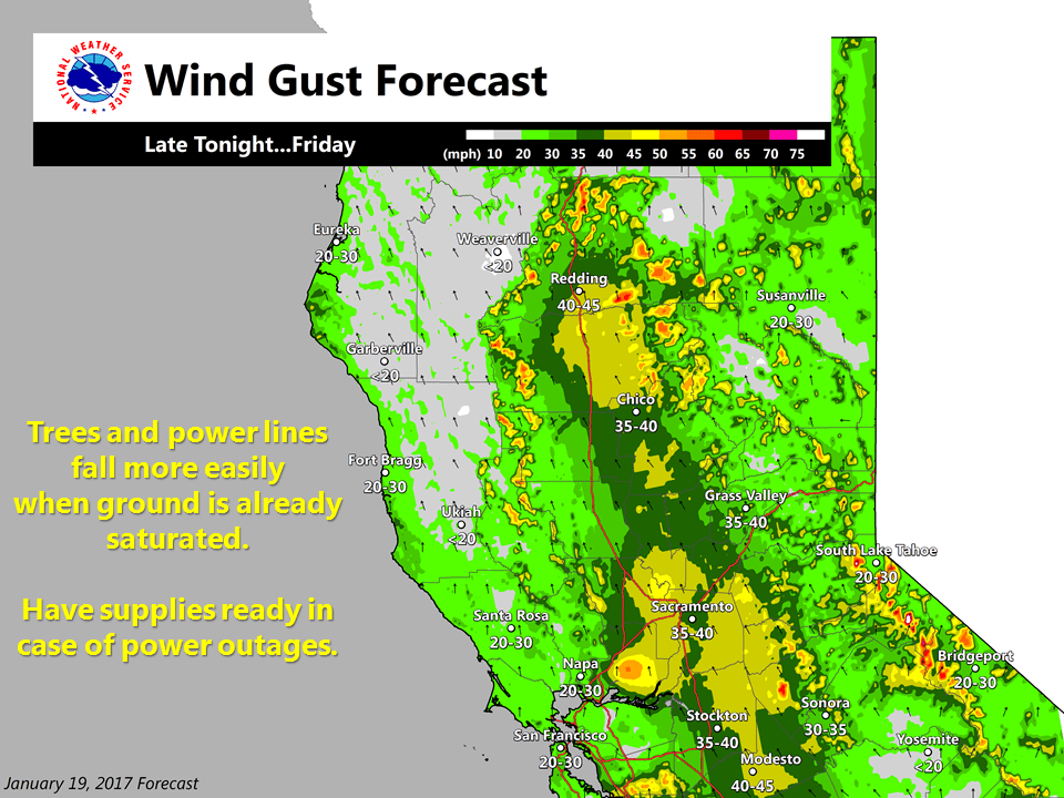
Showers and isolated thunderstorms will continue through the evening, with a few heavier bursts of snow over the mountains. Snow levels have dropped as low as as 3000 feet, but should generally remain between 3500-4000 feet. South to southeast winds will again increase around midnight under 45-55 kt 925 jet max. This will translate to 30-35 mph winds with a few gusts to 50 mph over the Sacramento valley Redding to Modesto into mid-day Friday. These type of winds will likely down trees and power lines, especially those weakened by yesterday’s strong winds. Power outages will be possible late tonight and Friday morning.
Snow showers will continue over the Sierra this evening with a few more inches, much heavier band will move in beginning around 4 am continuing into Friday with 1 to 3 feet possible above 4000 feet through Saturday morning. Snow levels may dip to 3000 feet at times in the heavier precip bands. Valley rainfall of 0.50 to 1 inch are forecast. Have added isolated thunderstorms to the Friday afternoon forecast as enough clearing may open up for destabilization over valley locations.
January 19, 2017 at 9:07 AM The National Weather Service in Sacramento has issued a wind advisory, which is in effect from 1 am to 1 pm Friday. Strong winds in the Central Valley and Sierra Foothills late tonight into early Friday.
January 19, 2017 at 9:06 AM Caltrans: Highway 50 traffic has been released to go over Echo Summit with chain controls in effect.
January 19, 2017 at 8:19 AM Caltrans: Highway 50 over Echo Summit is closed from Sly Park to Meyers due to avalanche control. No ETO.
January 19, 2017 at 8:06 AM Only a few persistent power outages in our area: 85 homes at the end of Newtown Road near Jones Bar Road, due to a downed power line. Crew is on scene. 28 customers on Old Downieville Highway and American Hill Road in Nevada City where trees fell on the power lines. 36 homes on Sages Road on the San Juan Ridge, so far PG&E is unable to access the affected equipment. 55 homes on Weimar Cross Road in Weimar, PG&E repair crew is on-site working to restore power. 68 customers in Dutch Flat mostly near Frost Hill Place and Ridge Road, PG&E assessment crew is en route to the outage.
January 19, 2017 at 7:44 AM Showers, thunderstorms today – next storm arrives Friday. Only a brief break in the active weather pattern is expected today and not that much of a break considering the threat of thunderstorms today and mountain snow showers. Another moderate to strong weather system is forecast to push through the north state on Friday bringing another round of heavy rain, strong winds and mountain snow. This system will linger into Saturday morning. Any break Saturday afternoon will be brief with yet another strong storm system expected to move into Norcal late Saturday night and early Sunday. Showers will continue into Monday. Northern California may finally see a significant break in the wet windy weather pattern around the middle of next week where several days of dry weather are expected.

January 18, 2017 at 11:38 PM Earlier today near Alta Sierra, reader Toni was quite lucky. Yes the tree fell over, but it missed the house and the propane tank.
January 18, 2017 at 11:24 PM Idaho Maryland Road near Tranquility Lane is blocked by a tree in the roadway.
January 18, 2017 at 10:41 PM Power has been restored to most of the 3,218 customers in the Nevada City area.
January 18, 2017 at 10:22 PM Multiple PG&E crews are out trying to isolate trouble spots and restore power. Numerous trees falling into power lines, some in very hard to access lovations, have caused a near total outage for the Nevada City area. The number of customers affected is approximately 3,218.
January 18, 2017 at 9:57 PM Now widespread reports of power outages in Nevada City and surrounding areas. Crews are being dispatched, spare a thought for these workers out in this weather. Be prepared for an extended outage and treat any downed power lines as live – don’t touch or drive over them.
January 18, 2017 at 9:50 PM Power outage affecting the Lake Vera and North Bloomfield area, no cause or estimated time of restoration. Possible transformer explosion reported near North Bloomfield and Coyote Street just outside Nevada City. Also a report of power outage on Zion Street in Nevada City
January 18, 2017 at 9:24 PM Power outage affecting 85 PG&E customers on Newtown Road near Jones Bar Road and Empress Road. No cause or estimated time of restoration yet.
January 18, 2017 at 6:45 PM Tree into the power lines off Rollins Lake Road.
January 18, 2017 at 6:11 PM CHP Truckee: I-80 has re-opened on both directions.
Chain Control:
I-80 is R2 Truckee to Baxter.
I-80 is closed for all tractor trailer combinations at the Nevada State Line for westbound traffic and at Applegate for eastbound trucks.
January 18, 2017 at 6:08 PM 457 homes out of power after trees fell into the power lines on Willow Glenn Road in the Challenge area in Yuba County. 354 homes along La Porte Road in the Rackerby area and Swedes Flat are also without power.
January 18, 2017 at 6:05 PM Power outage affecting 53 customers on Streeter Road near Higgins Corner. A broken pole has been found. 118 homes off Valley Road in Meadow Vista are out of power. No cause yet.
January 18, 2017 at 5:34 PM Possible overturned vehicle on Rough&Ready Highway. Units are en route, attempting to locate the accident.
January 18, 2017 at 5:32 PM Caltrans: I-80 Holding traffic WB at DLI and EB at numerous locations due to multiple spin outs over the summit & Low visibility .
January 18, 2017 at 4:50 PM Take it slow on Hwy 20. Snow is beginning to accumulate near 3,500 ft.
January 18, 2017 at 4:39 PM A very determined Hummingbird is not deterred by gusty winds and rain in Rough&Ready, Calif. Video courtesy of 13clicks.
January 18, 2017 at 4:38 PM I-80 CLOSED: Westbound at Truckee
CLOSED: Westbound at DLI (Donner Lake Interchange)
EAST(R2): 1 Mi E. of Baxter(150) to Truckee(184)
January 18, 2017 at 4:04 PM Wind advisory now in effect until midnight tonight. A Pacific front is bringing strong southerly winds to the Central Valley and Sierra Foothills.
Sustained southerly winds greater than 25 mph with gusts to 50 mph.
January 18, 2017 at 3:56 PM Pro tip: Charge your devices – power outages are likely. Also, turn your car’s headlights on when windshield wipers are on!

January 18, 2017 at 11:41 AM Road conditions over Donner Summit are rapidly deteriorating. Bring chains, warm clothes and patience.
January 18, 2017 at 11:05 AM CHP Truckee: Chain Control on I-80, Kingvale to Donner Lake Rd. in both directions.
January 18, 2017 at 10:39 AM Tree into the power lines at the intersection of New Rome and Grunt Hill Road outside of Nevada City. 133 customers affected from New Rome to Hudson Way. Crews are on scene, estimated time of restoration is noon today.
January 18, 2017 at 9:37 AM First in a series of storms arrives with gusty winds. A series of storms moving across the Pacific will bring periods of rain and heavy mountain snow to northern California over the next several days. The periods of heaviest precipitation will be today into Thursday morning, Friday into Friday night and Sunday into Monday. Renewed flooding will be possible at the lower elevations with travel impacts likely over the mountains.
January 18, 2017 at 8:53 AM Caltrans is alerting motorists that a four-mile section of State Highway 89 on either side of Emerald Bay remains closed because of heavy snowfall and debris on the roadway. Caltrans maintenance staff has begun working to clear the highway, which is buried in up to 30 feet of snow in some locations.
January 17, 2017 at 5:40 PM Engineering firm Holdrege&Kull has posted another astonishing video of the sinkhole in Grass Valley near Liberty Motors. The seven day progression shows the unstable terrain, the widening and deepening of the hole – and the efforts of city, county and private contractors to stabilize the banks before the next incoming storms.

January 17, 2017 at 2:01 PM Slope stabilization work is underway at a massive sinkhole in Grass Valley. The sinkhole appeared during the last storm behind Liberty Motors in Grass Valley and was reportedly caused by a clogged city drain pipe.
January 17, 2017 at 12:06 PM Banner Quaker Hill is now open again. The hazard tree has been felled.
January 17, 2017 at 11:28 AM At 9am today, the Nevada County Department of Public Works closed Banner Quaker Hill near Cascade Shores. Public Works will be providing traffic control for PG&E to safely remove a 120-foot tall dead tree located on private property near the roadway. This tree recently caused the County to close Banner Quaker Hill during the recent storm activity and poses a safety risk to local residents, overhead utilities, and nearby traffic. We expect the work to be completed and the road to be opened to traffic before the end of the day. Road crews will be onsite to divert traffic away from the closure and tree removal area.
January 17, 2017 at 7:58 AM Series of storms to bring rain and heavy mountain snow. The periods of heaviest precipitation will be Wednesday into Thursday, Friday and Sunday into Monday. Renewed flooding will be possible at the lower elevations with travel impacts likely over the mountains
January 16, 2017 at 12:53 PM CHP Truckee: We are currently working a traffic collision with a vehicle rolled over on I-80 westbound at Soda Springs. The right hand lane is currently blocked. Expect slow traffic in the area. Also traffic is beginning to pick up on SR-267 and SR-89 as the holiday weekend traffic heads home. Have patience and Drive safely.
January 16, 2017 at 9:57 AM Vehicle in to a tree, no injury to humans reported, on Cherry Creek Road and Hwy 49.
January 16, 2017 at 9:20 AM Non-injury accident on Hwy 49 near Alta Sierra Drive.
January 16, 2017 at 8:29 AM Traffic signals not working on Hwy 19 and Combie Road in the Higgins area.
January 16, 2017 at 7:22 AM Dry through Tuesday, then stormy for a week. Wet pattern returns Wednesday with a series of storms that will impact NorCal into early next week. Snow levels should lower into the foothills by the end of the week. Be prepared for wind and hazardous mountain travel.
January 15, 2017 at 11:57 AM A large fog bank has rolled into western Nevada County. Visibility will decrease significantly. If driving, turn your headlights on.
January 14, 2017 at 10:01 AM Placer County K-9 Deputy Chase here, I wanted to tell all those headed to North Shore Lake Tahoe and the slopes to bring your patience.
January 14, 2017 at 9:57 AM Sunny and dry weekend. Dry weather has returned to NorCal and will continue through Monday. Patchy dense fog possible in the overnight and early morning hours. Keep in mind that river and stream levels are still elevated, but will gradually recede. Confidence increasing that another atmospheric will arrive sometime on Tuesday with widespread precipitation on Wednesday and Thursday. Snow levels will initially be high, then lower by the end of the week. Models suggest that wet pattern could continue into the weekend.
January 13, 2017 at 2:19 PM The Department of Water Resources (DWR) is increasing flows to the Feather River in hourly increments between 2 p.m. and 4 p.m. today. Total Lake Oroville outflow will increase from 13,300 cubic feet per second (cfs) to 20,000 cfs. Flow will be routed through Hyatt Powerplant and also through the Oroville Dam Spillway. Spillway flows will reach 10,000 cfs.
January 13, 2017 at 12:11 PM Non-injury accident on Old Tunnel Road off Brunswick Road in Grass Valley.
January 13, 2017 at 11:55 AM Avoid the Hwy 20 overpass near South Ponderosa in Grass Valley. Law enforcement activity, a possible jumper on the bridge.
January 13, 2017 at 8:48 AM Take it slow! Roads are still icy this morning, several accidents reported already.

January 13, 2017 at 8:39 AM Ice on the roadway blamed for a solo vehicle spin-out on Bitney Springs Road near the Rough&Ready Highway in Grass Valley.
Road conditions will improve during the day, but please slow down and watch for patches of ices. By tonight, fog is likely once more, reducing visibility.
January 13, 2017 at 7:57 AM Sunny and dry with slight warming over the weekend. Dry weather has returned to NorCal and will continue through Monday. Patchy dense fog possible in the overnight and early morning hours. Keep in mind that river and stream levels are still elevated, but will gradually recede. Confidence increasing that another atmospheric will arrive sometime on Tuesday with widespread precipitation on Wednesday and Thursday. Snow levels will initially be high, then lower by the end of the week. Models suggest that wet pattern could continue into the weekend.

January 13, 2017 at 7:30 AM Smoothly sailing on Hwy 20 this morning, reports reader Erin Thiem.
January 12, 2017 at 10:51 PM Thanks to Holdrege &Kull for sharing their aerial footage of the rather large sinkhole near Wolf Creek in Grass Valley.
January 12, 2017 at 10:50 PM Per Caltrans: I-80 is closed over the summit due to low hanging power lines from Kingvale to Truckee. ETO 11:30 pm. PG&E crews are on scene.

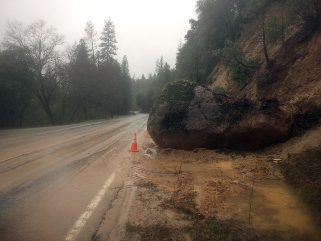
January 12, 2017 at 2:18 PM Expect up to a 15-minute delay on Hwy 49 between North San Juan and Oregon Creek. Caltrans is moving some really big boulders out of the roadway. Thanks to reader Eben Dodd for the photo.
January 12, 2017 at 1:25 PM First unit arrived at Oakhurst Drive, confirms this is a false alarm. All incoming units are being canceled.
January 12, 2017 at 1:21 PM Report of a possible structure fire Hwy 49 and Oakhurst Drive near Rincon Way. Numerous engines en route.
January 12, 2017 at 1:05 PM Hwy 20 near White Cloud is open again.
January 12, 2017 at 12:45 PM Hwy 20 at White Cloud is closed due to 4-vehicle crash and vehicle recovery. No detour and no ETO.
January 12, 2017 at 12:16 PM Large rocks in the roadway near the Gold Flat off ramp on westbound Hwy 49. Use caution in the area.
January 12, 2017 at 12:13 PM Update from CHP Grass Valley: The roadway is clear and traffic should be returning to normal. Our officers are continuing the investigation into what caused this collision. Preliminary findings indicate the driver of a Honda SUV crossed into the northbound lane. Multiple northbound vehicles were able to avoid the Honda but it then collided head-on with a Jeep SUV. It is unknown if drugs/alcohol were a factor in this collision. Toxicology results are pending in the coming weeks. Next-of-kin notifications are currently being made to the families.

January 12, 2017 at 11:47 AM Spillway release on Bullards Bar in Yuba County. All 3 spillways going full blast. Photo courtesy Shirley DicKard, Editor, The Camptonville Courier.
January 12, 2017 at 11:22 AM Hwy 49 is open again in both direction after a fatal accident near La Barr Meadows. Traffic delays should resolve shortly.
January 12, 2017 at 10:27 AM Heavy traffic congestion due to the closure of Hwy 49. Use Hwy 174 to get to Auburn. Per Nevada County Fire JOA: All fire units are clear of the double fatality vehicle accident on Hwy 49. CHP remains on scene with CalTrans Hwy to reopen soon.
January 12, 2017 at 10:02 AM CHP Grass Valley: Hwy-49 fatality collision: 2 vehicles involved, solo male drivers – both deceased. Lanes blocked for another hour minimum.
January 12, 2017 at 9:19 AM Dry weekend, possible storm on Wednesday. One last system will bring relatively light rain to the lower elevations today with a few inches of snow over the Sierra. Dry conditions expected Friday afternoon through Monday. Next chance of precipitation next Tuesday with heavier precipitation possible the middle of next week.
January 12, 2017 at 8:55 AM Accident on Hwy 49 near Alta Sierra Drive now reported as a fatality. All lanes blocked in both directions.
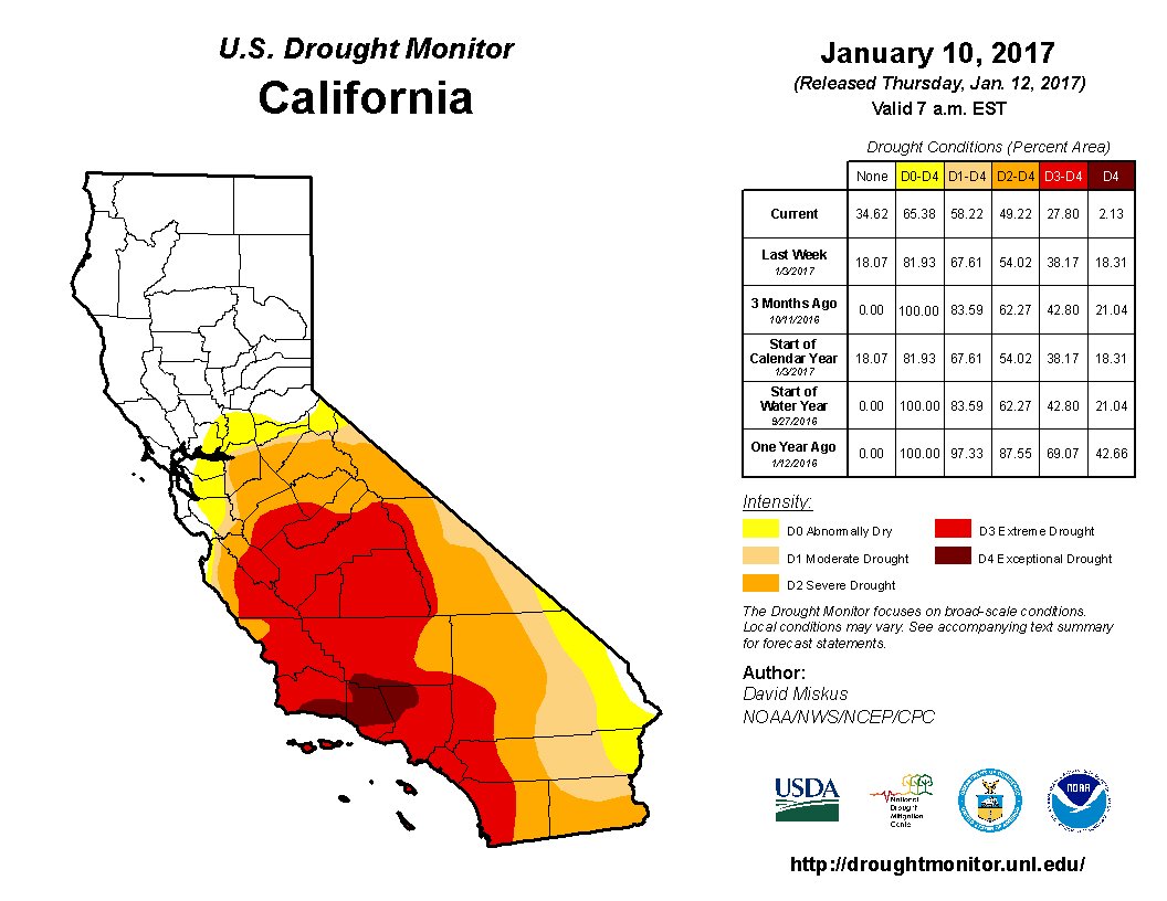
January 12, 2017 at 8:51 AM Copious rain from CA storms has improved drought conditions in NorCal but extreme to exceptional drought remains in SoCal.
January 12, 2017 at 8:26 AM Head on collision on Hwy 49 at La Barr Meadows outside of Grass Valley. Emergency services on scene. Northbound lanes partially blocked.
January 12, 2017 at 8:08 AM Just confirming: Hwy49 is OPEN again in Nevada County, with no restrictions Note: SR-49 in Yuba and Sierra Counties still closed, per CHP Grass Valley.
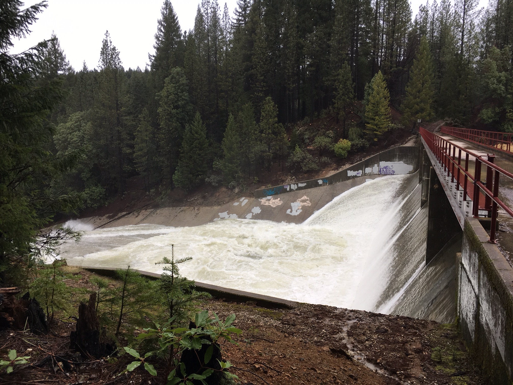
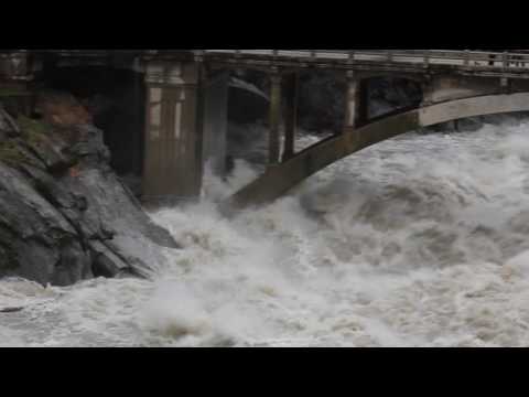
January 11, 2017 at 6:36 PM Thanks to Peter Gammelgard for sharing today’s photo of the Scotts Flat spillway.
January 11, 2017 at 4:37 PM Caltrans Donner Pass Area Superintendent Dave Wood provides an update on snowy I-80 travel.
#TrafficAlert Donner Pass Area Superintendent Dave Wood provides an update on snowy I-80 travel. pic.twitter.com/u5yHXrex5e
— Caltrans District 3 (@CaltransDist3) January 12, 2017
January 11, 2017 at 4:21 PM A sinkhole has appeared on Brunswick Road in the middle of the roadway between Greenhorn and Woodrose, affecting both lanes.
January 11, 2017 at 11:42 AM CHP Gold Run shared this from Morten Road washout, near Alta exit of Interstate 80. Stay out of area. I-80 remains closed.
January 11, 2017 at 11:40 AM San Juan Ridge area, Grizzly Hill Road at Spring Creek has flood waters over the road. Two inches deep and eroding the road rapidly, according to reader Michael.
January 11, 2017 at 10:32 AM Power outage on the San Juan Ridge has been reduced to 698 homes. PG&E crews are on site, accessing the trouble spots.
January 11, 2017 at 9:34 AM No estimated time of restoration available for the outage affecting 1,130 homes on the San Juan Ridge yet. PG&E is unable to access the affected equipment.
January 11, 2017 at 9:33 AM Estimated time of restoration for 226 homes along Indian Springs Road in Grass Valley is 3:00 pm. Field personnel have found a downed power line. Crews are on site.
January 11, 2017 at 9:31 AM Estimated time of restoration for the remaining 75 homes in the Starbright Acres area of Grass Valley is 4:00 pm. Trees are in contact with electrical equipment. PG&E repair crew is on-site working to restore power.
January 11, 2017 at 9:30 AM Power lines reported down on Rollins Lake Road.
January 11, 2017 at 8:15 AM Reader Diane Anderson sent these photos from the South Yuba River State Park at Bridgeport. January 11, 2017 at 10:02 AM Update: This is not a State Parks property, it is part of the Army Corps of Engineers land near Englebright Reservoir.
For people familiar with the park and the hike to Point Defiance at the confluence of the South Yuba and Yuba River, where Englebright Reservoir begins, there are several nice campsites and even a large group picnic area.
The picnic area has a large wooden pavilion covering the tables that stands 9-10′ high at the peak along with an outhouse beyond it.
We were shocked to find this as we hiked to the point yesterday. Yes, those are the roofs of both buildings.
January 11, 2017 at 8:13 AM Firefighters on scene at Taco Bell have found one light fixture smoking, they can handle it, all incoming units are canceled.
January 11, 2017 at 8:10 AM First unit has arrived on Olympia Park Drive, reports nothing showing from the outside, everybody out of the building.
January 11, 2017 at 8:07 AM Commercial structure fire reported at Taco Bell on Olympia Park Drive in the Brunswick Basin. Numerous engines en route.
January 11, 2017 at 7:47 AM Among the numerous problems on Hwy 49, this boulder one mile north of North San Juan. As a reminder, Hwy 49 is still closed between Nevada City and North San Juan. Use Pleasant Valley Road as a detour – while watching for boulders and debris in the roadway.
Thanks to reader Eric Clausen for the photo.
January 11, 2017 at 7:31 AM I-80 at Kingvale right now.

January 11, 2017 at 7:28 AM Placer County: North Tahoe offices closed today due to power outage and blizzard conditions.
January 11, 2017 at 7:27 AM Hwy 49 in Sierra County is closed from Yuba Pass to Sattley due to numerous rock and mudslides.
January 11, 2017 at 7:13 AM CHP Truckee: I-80 remains closed this morning from the Nevada State Line to Colfax.
Locals trying to come to Truckee and employees trying to come to Truckee are permitted. Same for people leaving Truckee back to Reno.
We will bring you more information on I-80 as things change. As of right now it will not open until conditions improve.
SR-267 between Kings Beach has re-opened. However it is R2 Chain Control.
SR-89 north, north of Hobart Mills is closed due to down trees. Estimated time of re-opening is 8:00 am.
January 11, 2017 at 7:03 AM Due to unsafe and unpredictable conditions as a result of the storms the following schools are closed.
Nevada Joint Union High School District schools are closed today.
Nevada City School District schools are closed today.
Yuba River Charter School
Sierra Montessori Academy
Seven Hills Middle School
Pleasant Ridge School
Nevada Union High School
Magnolia Intermediate
Grizzly Hill School
Ghidotti Early College High School
Cottage Hill School
Bear River High School
Alta Sierra School
January 11, 2017 at 6:54 AM Debris and mudslide in the roadway at Brooks Road near Rattlesnake Road in Grass Valley. Roadway is closed.
January 11, 2017 at 6:48 AM The closure at the intersection of Broad, Nevada, Sacramento and Boulder Streets in Nevada City has been lifted.
January 11, 2017 at 6:22 AM Showers today, more mountain snow – let the cleanup begin. Rain and snow continues today into Thursday, but will be on the decline as the forecast is now more showery instead of widespread precipitation. Please keep in mind that NorCal will still be feeling the effects of our recent storms over the next several days even after precipitation stops. Saturated soils could still shift causing mud or rock slides, sink holes and downed trees.
January 11, 2017 at 6:06 AM CHP Grass Valley traffic update for Hwy49 north of Newtown Rd (Nevada City): CalTrans is still working to clear multiple slides. Closure still in effect.
January 10, 2017 at 11:20 PM Tree blocking the roadway on Perimeter Road near McCourtney Road.

January 10, 2017 at 10:31 PM The Broad Street intersection right now. According to reader Greg the water is against the building at Lefty’s Grill.
January 10, 2017 at 10:06 PM Flooding reported on Slate Creek just past the intersection with Ridge Road in Grass Valley.
January 10, 2017 at 9:55 PM Outage from Higgins Corner to Retrac Way down to Perimeter Road south of Grass Valley affecting 2,057 homes.
January 10, 2017 at 9:28 PM Tree down across Pekolee Drive, blocking the roadway. Alternate route to access Pekolee and Maranatha would be Little Deer, according to reader Gary – and thank you for the heads up.
January 10, 2017 at 9:09 PM Roadway blocked by a downed tree on Combie Road near Magnolia Road in the Higgins area.
January 10, 2017 at 9:07 PM Power outage on Perimeter Road affecting 48 customers and a new reader report of a power outage on Wolf Road near Wolf Creek south of Grass Valley
January 10, 2017 at 8:27 PM Nighttime water rescue near North San Juan successful. Many thanks to all the agencies who participated.
January 10, 2017 at 8:19 PM Tree in the roadway on Rock Creek and Rector Road in the Lake Vera area outside of Nevada City.
January 10, 2017 at 8:17 PM Power outage in North San Juan and on the San Juan Ridge affecting 1,130 customers. PG&E crew en route to the outage.
January 10, 2017 at 7:55 PM Tree and rocks in the roadway on Rollins Lake Road near You Bet Road.
January 10, 2017 at 7:50 PM Very large tree leaning over the roadway on Brunswick Road between Loma Rica and Greenhorn in Grass Valley. A truck could hit the tree if driving under.
January 10, 2017 at 7:32 PM Indian Springs Road can be accessed from McCourtney Road.
January 10, 2017 at 7:10 PM Tree in the roadway on Indian Springs Road near Spenceville Road. The road is closed in both directions, per Nevada County Fire JOA.
January 10, 2017 at 7:06 PM 411 customers out on Polaris Drive and Starbright Acres in Grass Valley. 227 customers out along Indian Springs Road in Grass Valley.
January 10, 2017 at 6:52 PM Power outage in the McCourtney/Polaris Drive area, also affecting customers along Indian Springs Road in Grass Valley. Tree into the power lines.
January 10, 2017 at 6:42 PM The East Broad Street off ramp at Hwy 49 is now closed due to flooding. In Nevada City the intersection of Broad Street, Sacramento Street, Nevada Street and Boulder are closed closed due to flooding. Absolutely no through traffic.
January 10, 2017 at 6:41 PM Hwy 174 is open again in both directions. Hwy 49 is closed between Nevada City and North San Juan. Also closure near Goodyears Bar and Sierra City. I-80 remains closed for the night. Hwy 20 is open to local traffic only from Nevada City to the Town of Washington.
January 10, 2017 at 6:33 PM Hwy 174 is fully open again in both directions at the Bear River bridge after the mudslide.
January 10, 2017 at 6:23 PM Water rescue on Murphy Road is ongoing. Please use extreme caution in the Tyler Foote area and watch for fire equipment.
January 10, 2017 at 6:21 PM Power outage in Downieville, Sierra City, Bassets up to Haskell Creek. PG&E is unable to access the outage site due to numerous rock and mudslides and the closures on Hwy 49. No estimated time of restoration.
January 10, 2017 at 6:01 PM Heads up: A tree fell across Oak Street in Grass Valley taking down power lines. Live wires across Oak Street. Avoid cutting through Oak Street off Squirrel Creek to Walker St. in Grass Valley. PG&E has been notified. Thanks to reader Tiffni for the info!
January 10, 2017 at 5:49 PM North San Juan Fire units have arrived on scene at Murphy Road, reporting one patient in a vehicle approximately 50 ft down the embankment. Additional rescue units are en route. The incident is close to Tyler Foote Road.
January 10, 2017 at 5:47 PM Vehicle vs a pole on Hwy 49 at Little Valley Road. Emergency services are en route.
January 10, 2017 at 5:44 PM Water rescue, North San Juan engines, ambulance en route to a vehicle accident, vehicle in a ditch on Murphy Road, across of Milhous Drive. Report by passerby of a person trapped.
January 10, 2017 at 5:25 PM Flooding and mud on Ridge Road at the Rough&Ready Highway intersection in Grass Valley.
January 10, 2017 at 5:22 PM The Hwy20/49 eastbound freeway off-ramp to Broad St has been reopened. NCPD officers are still on-site, but the ramp is clear.
January 10, 2017 at 4:58 PM Per CHP Grass Valley: Banner-Quaker Hill Rd is closed entering Cascade Shores area due to dangerous/hanging tree. Use Pasquale Rd as alternate.
January 10, 2017 at 4:45 PM Road update: Hwy 49 remains closed between Nevada City and North San Juan, use Pleasant Valley Road as an alternate route. Southbound 49 at Downieville closed due to a slide. Hwy 49 in Sierra City closed due to a slide.
January 10, 2017 at 10:28 AM Hwy 49 is blocked in both directions near the Independence Trail due to rocks and tree across all lanes.

January 10, 2017 at 9:42 AM CHP Truckee posted this photo from Donner Summit just now. Yes, I-80 is closed in both directions.
January 10, 2017 at 9:38 AM Hwy 49 in Sierra County is closed in both direction on the North Yuba River bridge due to a landslide. Estimated time of reopening is noon today.
January 10, 2017 at 9:26 AM The Flood Warning continues for the Middle Fork Feather River near Portola until Wednesday afternoon.
* At 8:30 AM Tuesday the stage was 9.3 feet.
* Flood stage is 8.5 feet.
* Minor flooding is occurring and Minor flooding is forecast.
* Forecast: The river will continue to fall to below flood stage by Tuesday evening.
* Impact: At 9.5 feet, moderate flooding of lowlands, roads and low-lying structures in reach from Beckwourth to Sloat including Portola. In Portola, areas near the river along highway 70 experience some minor flooding. The south end of West Street floods. Highway 89 near Clio flooded.
January 10, 2017 at 9:23 AM NWS Sacramento: Another Atmospheric River storm will impact the area Today through Wednesday. Besides flooding, the major concern is blizzard conditions over the Sierra today through early Wednesday. Closures and significant travel hazards for mountain areas and severe whiteout conditions.
Winds: Valley gusts 40 to 60 mph
Mountain ridge-top gusts 50 to 70 mph
January 10, 2017 at 9:09 AM By a unanimous vote, Hank Weston is the new Chair of the Nevada County BOS, Ed Scofield was unanimously selected as Vice Chair.
January 10, 2017 at 9:06 AM Based upon the National Weather Service issued blizzard warning, the Lake Tahoe Basin Management Unit offices in South Lake Tahoe and Incline Village are closed today and tomorrow. We plan to re-open on Thursday morning, conditions permitting. A National Weather Service blizzard warning has been issued at http://go.usa.gov/x9QDg.
January 10, 2017 at 8:58 AM Tree leaning over the roadway, about to fall on northbound Hwy 49 at Quail Creek Road just outside of Grass Valley. Emergency services en route.
January 10, 2017 at 7:47 AM Mudslide and trees in the roadway on southbound Hwy 49 just north of the Yuba River Bridge. Lanes are partially blocked.
January 10, 2017 at 7:18 AM Heavy rain and snow today, flooding continues. Here comes the next Atmospheric River! Continued flooding concerns, Sierra blizzard conditions and very heavy snow, and strong southerly winds are all on the plate today into Wednesday.
January 10, 2017 at 6:50 AM Extensive roadway flooding in Nevada and Placer counties reported. Hwy 20 in Nevada City and Hwy 174 in Grass Valley open to local traffic only. Whiteout conditions reported on Hwy 20 past White Cloud campground. Give yourself extra time for the morning commute.

January 9, 2017 at 11:08 PM I-80 is closed from Colfax to the Nevada stateline (both directions) due to whiteout conditions.
January 9, 2017 at 5:03 PM Bullards Bar Reservoir is closed until further notice, per Yuba County Water Agency.

January 9, 2017 at 4:45 PM What used to be Maybert Road in the Town of Washington. Thanks to Philip Copening for the photo
January 9, 2017 at 4:34 PM Based on the NOAA weather forecast for the region, the Rubicon Trail will remain CLOSED through Thursday, January 12, 2017. This extension is due to continued flooding impacts and significant Sierra snow being forecast. The closure is to protect the resources and for public safety.

January 9, 2017 at 2:25 PM Thanks to Mary West for this unsettling photo!
“Funnel cloud happening now. West of the Casino in Placer County. Looking toward Rio Linda?”

January 9, 2017 at 2:23 PM Still flooding: Doty Creek near Lincoln in Placer County. Thanks to reader Sharon Jones for the photo
January 9, 2017 at 2:12 PM A short video we shot this morning near the 49er Bridge on the South Yuba

January 9, 2017 at 1:15 PM A big landslide in the parking lot has prompted the closure of the 49er Bridge State Park temporarily. More rock slides are highly likely, watch out for trees, mud and debris flows.
January 9, 2017 at 9:30 AM Tree into the power lines on Hwy 49 near Tyler Foote. The tree and the power lines are hanging over the roadway. North San Juan Fire en route.
January 9, 2017 at 9:09 AM The latest update on Greenhorn Creek by Daniel Ramey, the PIO for Peardale Chicago Park Fire. Great info on the current situation. Greenhorn Creek rose 3 feet in the past 19 hours! Normally, Greenhorn Creek is 10 ft wide and 2 ft deep.

January 9, 2017 at 8:36 AM Power outage in North Auburn affecting 1,153 homes along Auburn Ravine Road. No estimated time of restoration yet. 109 customers out on Vineyard Road, estimated time of restoration is 1:00 pm.
January 9, 2017 at 8:27 AM Cleanup continues with more rain and high wind tomorrow. Flooding, mudslides and downed trees likely.
January 9, 2017 at 7:24 AM 917 customers from the top of Banner Mountain Trail to Scotts Flat Road in Nevada City out of power. Found a broken power poles in the area PG&E crews are on scene. No estimated time of restoration yet.
January 9, 2017 at 7:22 AM Power lines down and across the road on Del Mar Way at Piper Lane in the Penn Valley area. Emergency services en route.
January 9, 2017 at 7:21 AM Hwy 20 remains closed to eastbound traffic from Nevada City to the junction of I-80 due to a mud slide. Local traffic is OK.
January 9, 2017 at 7:03 AM Showers today, high winds and heavy rain/snow on Tuesday. Showery weather is expected across the region today. Another wet storm system will arrive Tuesday into Wednesday. 1 to 2 inches of additional rainfall is expected across the Valley, with 2 to 5 inches over the mountains. Flooding will continue to be a problem with rivers and streams running high.
January 8, 2017 at 10:57 PM Flooding is making access and egress impossible for the Serene Lakes community. No estimated time for reopening the road.
January 8, 2017 at 10:27 PM Small slide impacting the westbound lane of Rollins Lake Road, one mile from the lake.
January 8, 2017 at 10:26 PM Power lines down, over the roadway, near Rices Crossing on Marysville down.
January 8, 2017 at 10:09 PM Tree leaning towards a home on Alta Sierra Drive, firefighters en route for standby.
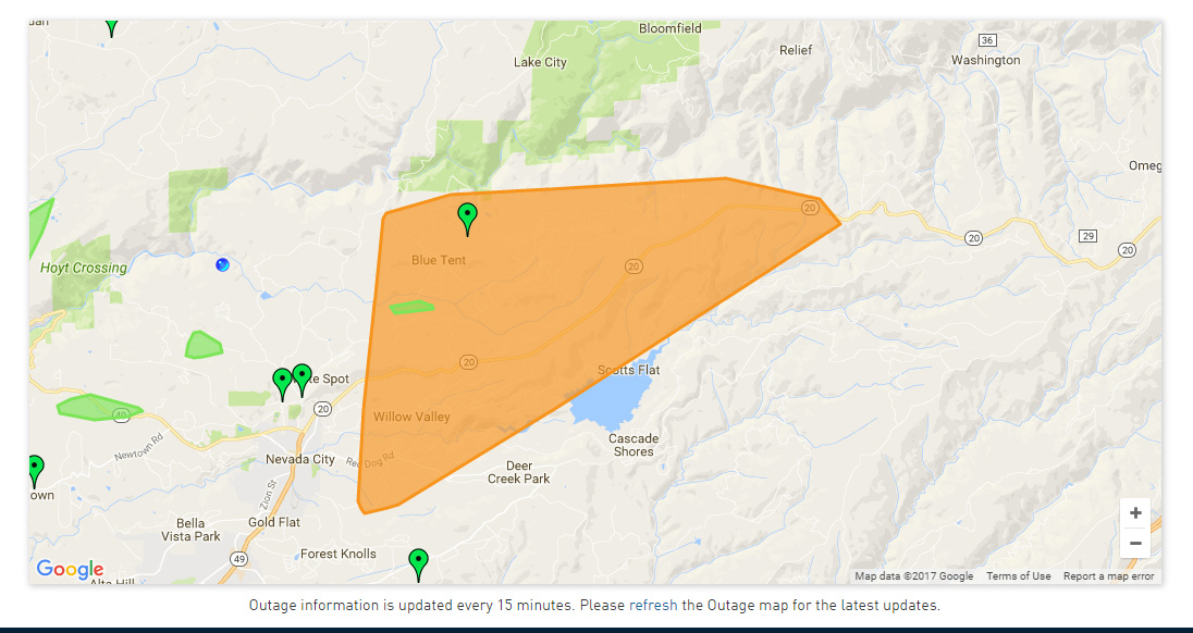
January 8, 2017 at 9:44 PM Reported power outage for 2,111 customers in an area extending from Gold Flat in Nevada City, through Deer Creek Park, Scotts Flat, Cascade Shores up to Blue Tent and along Hwy 20.
January 8, 2017 at 9:34 PM A reminder from Caltrans: I-80 eastbound closed from Colfax due to down power lines near the Donner Lake interchange mudslide area.
January 8, 2017 at 9:26 PM Tree down across the road on Hwy 49, 3/4 mile north of Petersons Corner near North San Juan.
January 8, 2017 at 8:43 PM Tree in the roadway, blocking the road on Auburn Road in Grass Valley.

January 8, 2017 at 8:16 PM Not a good idea to get this close to the South Yuba. These rocks are slippery.
January 8, 2017 at 8:06 PM Tree down on Greenhorn Road near Anvil Road in Grass Valley. The roadway is blocked.
January 8, 2017 at 8:03 PM Update from the Town of Washington: “Report of a rock slide on Washington Road. The low spot on Maybert Road is washed out according to up river John. Numerous culverts blocked. Washington Fire Department did road cleanup and access for a good part of the day. Washington is holding strong so far.” Thank you Katy!
January 8, 2017 at 7:48 PM Andrew Wilkerson shot this video around 4:15 pm today at the end of Red Dog Road.

January 8, 2017 at 7:01 PM Nimrod Street in Nevada City is being closed due to flooding.
January 8, 2017 at 6:19 PM Caltrans: westbound I-80 closed at the Donner Lake Interchange due to mudslide. No further info, no ETO.
January 8, 2017 at 6:14 PM Idaho-Maryland Road near Sutton Way in Grass Valley is flooded.

January 8, 2017 at 6:02 PM Tree blocking the roadway on Rock Creek Road above Hudson Way near Purdon Road outside of Nevada City.
Use extreme caution in the area, or better yet – stay home.
Photo courtesy Michael Schindler
January 8, 2017 at 5:48 PM Deer Creek in Nevada City is flooding, reaching Lefty’s Dining patio (again.) Nevada Street is closed at Broad Street.

Photo courtesy Karen Chizek.Flooding is expected to continue for the next three days.
The Flood Advisory has been extended by the National Weather Service in Sacramento to Wednesday for the Foothills and Motherlode.
Pioneer Park is partially flooded as well, please avoid any flooded areas anywhere.
You won’t be able to see the depth of flooding in the dark. Stay safe!

January 8, 2017 at 5:46 PM Boulders in the road and numerous slides reported on Purdon Road between Purdon Crossing and North San Juan.
January 8, 2017 at 5:35 PM One additional engine requested to the car under tree on Hwy 49 and Cameo Drive. Total of 4 engines responding, with medics.
January 8, 2017 at 5:35 PM Roadway completely flooded on Hwy 174 at Laws Ranch Crossing Rd, according to CHP Grass Valley.
January 8, 2017 at 5:27 PM Tree in the roadway, with a car partially stuck under the tree, on northbound Hwy 49 and Cameo Drive in the Higgins area. Emergency services are on scene.

January 8, 2017 at 5:18 PM Yuba river at Bridgeport near Penn Valley has doubled in width. North parking lot flooded at State Park.
Hwy 174 at Brunswick Drive in Grass Valley, the northbound lane is flooded. Public Works en route. Your local firefighters ask you to please obey all road closures and do not move any hazard tape or barricades.

January 8, 2017 at 5:12 PM Caltrans: Slide on SR 20 above Bear Valley west of 20/80 junction. Hwy 20 is closed until further notice.
January 8, 2017 at 5:03 PM Mud slide on Hwy 49 on the south side of the river. Traffic is down to one lane. CHP on scene for traffic control.
January 8, 2017 at 5:00 PM Gas light in Nevada City on North Pine Street is shooting flames, fire en route.

January 8, 2017 at 4:55 PM The South Yuba continues to rise. Please, do not risk your life for a selfie!
January 8, 2017 at 4:53 PM Tree in the Roadway on Pasquale Road near Mill Springs in Cascade Shores, roadway is not completely blocked.
Emergency services are en route. No power lines down.

January 8, 2017 at 4:10 PM Mudslide on Hwy 174 near the Red Frog in Colfax, cleanup in progress. Photo by intrepid contributor Mark Ferrero.
January 8, 2017 at 4:04 PM You Bet Road is flooded at Lost Lake Road. Major flooding, do NOT attempt to cross.
January 8, 2017 at 3:57 PM Numerous engines en route to a water rescue on Brewer and Sunset Boulevard West in Pleasant Grove. Unknown if the vehicle is occupied.
January 8, 2017 at 3:56 PM Power outage in Peardale reduced to 1,056 customers.
January 8, 2017 at 3:48 PM Tree blocking one lane on Bitney Springs Road near Newtown Road.
January 8, 2017 at 3:46 PM Per Truckee PD: Public Works crews, along with Nevada County Roads Department are closing Old 40 (Donner Pass Rd) from South Shore Dr to Sugar Bowl. There is a large amount of water across the roadway and concerns for undermining of the roadway. This is an area that often closes in storms and there are alternate routes available.
January 8, 2017 at 3:44 PM Flooding at the Bridgeport parking lot on the north Side of the Yuba River, with mud and rock slide.
January 8, 2017 at 3:37 PM Large pine tree in the roadway on Hwy 20 just east of Bowman Lake Road, the whole roadway is blocked.
January 8, 2017 at 3:34 PM Rollins Lake Road, going uphill towards Secret Town, rock and mudslide blocking the roadway.
January 8, 2017 at 3:33 PM The National Weather Service in Sacramento has extended the flood watch, now in effect through Tuesday afternoon.
January 8, 2017 at 3:16 PM Phone lines, not power lines down on Cruzon Grade, emergency services are on scene.

January 8, 2017 at 3:14 PM Camp Far West spillway carrying impressive amounts of water. Use extreme caution in the area.
January 8, 2017 at 3:09 PM Report of a tree blocking the roadway on Murphy Road, near Purdon Road. Tree blocking the roadway and power lines are down. North San Juan Fire en route.
January 8, 2017 at 3:00 PM Large tree and power lines down into a car on Dog Bar Road at Taylor Crossing Road, possible injuries. Emergency services en route.
January 8, 2017 at 2:59 PM Tree into a garage, power lines are down on Red Dog Road, no injuries.
January 8, 2017 at 2:58 PM Caltrans: :I-80 Nevada county ramps to highway 20 Nevada City & Grass Valley closed due to flooding use Hwy 174. No ETO.
January 8, 2017 at 2:57 PM Tree into power lines, power lines and tree in the roadway now at Bitney Springs near Starduster Drive in Grass Valley, emergency services en route.
January 8, 2017 at 2:40 PM Tree into power lines, Penn Valley Drive across of Spenceville Road. Emergency services en route.
January 8, 2017 at 2:23 PM Tree in the roadway on Hwy 49 at Lime Kiln Road, just outside of Grass Valley. Both southbound lanes blocked, one northbound lane also blocked.

January 8, 2017 at 2:22 PM Grass Valley CHP: SR-49 closed north of Downieville to Sierra City due to mud/rock slides and flooding. Only local residents allowed.
January 8, 2017 at 2:13 PM Power outage for 2,030 homes, all of Chicago Park and Peardale down to Dog Bar Road. PG&E has assigned a crew to assess the outage.
January 8, 2017 at 2:01 PM 48 homes without power along Hwy 49 near Shoshoni Trail Court.
January 8, 2017 at 2:00 PM Tree across the roadway on Old Downieville Hwy and Hwy 49. The road is completely blocked.
January 8, 2017 at 1:58 PM Power lines in the roadway on Greenhorn Access Road and Greenpeace lane. Emergency services on scene. Power is out to 111 homes.
January 8, 2017 at 1:40 PM Do not attempt to use Rock Creek Road as a bypass for Hwy 20. Car is blocking most of the roadway.
January 8, 2017 at 1:30 PM Another short video of Wolf Creek flooding.

January 8, 2017 at 1:17 PM A large tree across Hwy 20 between the Conservation Camp and the 5 Mile House. The roadway is impassible. Caltrans on site.
January 8, 2017 at 1:09 PM Overflow on Rollins Lake during the Jan. 8 2017 atmospheric river. Video by Mark Ferrero

January 8, 2017 at 12:55 PM Damage will be extensive (again) for homes on Wolf Creek.

January 8, 2017 at 12:54 PM Mud and rockslide on North Bloomfield/Graniteville Road near Coyote Street in Nevada City.
January 8, 2017 at 12:48 PM Roadway flooded on Morning Sun Lane and Dog Bar Road in front of Fire Station 22.
January 8, 2017 at 12:41 PM Power lines down and across the road on Rooster Hill Road, across from Hwy 49.

January 8, 2017 at 12:35 PM Flooding on Wolf Creek is getting worse. Our thanks to the residents for giving us access to their property – stay safe!
January 8, 2017 at 10:50 AM Two vehicles involved in an accident just north of the Bear River Bridge on northbound Hwy 49.
January 8, 2017 at 10:48 AM Power lines down in Grass Valley on Alta Street near Dolores. Emergency services en route.
January 8, 2017 at 10:43 AM Report of a residential structure fire, smoke in the house, in the Rough&Ready area. Numerous engines en route.
January 8, 2017 at 10:40 AM Power outage due to downed tree on Wheeler Acres Road affecting 44 homes. PG&E crew en route, emergency services on scene.
January 8, 2017 at 10:21 AM Tree in the roadway on Wheeler Acres Road in Grass Valley. Tree is blocking the road and power lines are down, emergency services en route.
January 8, 2017 at 10:20 AM CHP Truckee posted this video from I-80 and the Yuba.
January 8, 2017 at 10:11 AM Large tree completely blocking the roadway on Lakewood near Oakwood Circle in the Higgins/LoP area.
January 8, 2017 at 10:10 AM Boreal is closing down for the day due to weather.
January 8, 2017 at 10:08 AM Large tree in the roadway between Lake Wildwood Gate 1 and 2 on Pleasant Valley Road at Lake Wildwood Road.

January 8, 2017 at 10:01 AM Western Gateway Park in Penn Valley at 9 am.
January 8, 2017 at 9:50 AM Yuba County Current Road Closures:
Simpson Lane between 10th St. in Marysville and Hammonton-Smartsville Road in Linda.
Powerline Rd. between 9th Ave. and 11th Ave. in Olivehurst.
Iowa City Rd. between Fruitland Rd. and Loma Rica Rd.
Ramirez Rd. between Mathews Ln. and Fruitland Rd.
January 8, 2017 at 9:38 AM Tree across the roadway on Marysville Road near Dobbins. The road is completely blocked.
January 8, 2017 at 9:35 AM Yuba County has established an emergency shelter for those who need it in the Yuba College Cafeteria.
2088 N. Beale Rd. Marysville, Ca. 95901
January 8, 2017 at 9:25 AM 24 homes without power in Cascade Shores at Pasquale and Cascade Drive. PG&E is assessing the cause at the outage location.
January 8, 2017 at 9:17 AM Peardale Chicago Park Fire District PIO Daniel Ramey with the second update on conditions at Greenhorn Creek. Yesterday’s video is posted at the January 7, 2017 at 6:01 PM timestamp.

January 8, 2017 at 9:10 AM Eastbound I-80 at the Soda Springs off ramp, 2-3 inches of water across the roadway.
January 8, 2017 at 9:03 AM Caltrans: US 50 holding traffic at Twin Bridges, Meyers, Echo Summit, & Chiapa Dr. for avalanche control.no ETO.
January 8, 2017 at 8:59 AM Caltrans snapshot:
#CAflood:big water at South Fork of the Yuba looking east on I-80 near Cisco. pic.twitter.com/6LRBepfyq1
— Caltrans District 3 (@CaltransDist3) January 8, 2017
January 8, 2017 at 8:57 AM power outage affecting 114 customers on North Bloomfield Road from the Lake Vera/Purdon Road split to Bush Road. PG&E is assessing the cause at the outage location.
January 8, 2017 at 8:56 AM Report of plugged drain and roadway flooding on Jones Bar Road in Nevada City.
January 8, 2017 at 8:55 AM Heaviest precipitation today, heavy mountain snow Monday through Wednesday. Gusty south winds are expected with today’s storm. Downed trees, tree branches, and power outages will be possible, which could cause moderate-sized power outages.
January 7, 2017 at 6:01 PM Thanks to Daniel Ramey (PIOF) of the Peardale Chicago Park Fire Department for this update on Greenhorn Creek in Nevada County. Please be aware of the danger – avoid flooded areas.
January 7, 2017 at 5:47 PM NWS Sacramento: Very heavy rainfall is expected across NorCal on Sunday and flooding is certainly possible based on current forecasts. Be prepared.
January 7, 2017 at 2:33 PM Nevada County OES would like to inform citizens that we are critically low on sand bags and all remaining sand bags have been distributed to the various locations. In the past 24hrs more than 10,000 sand bags have been issued to the community. Citizens should bring their own sand bags to fill at the county distribution sites as sand will still be available.

January 7, 2017 at 10:51 AM Flood warning for the Cosumnes River at Michigan Bar Sun AM. The south bank levee near Wilton could overtop & flood
January 7, 2017 at 10:20 AM The Flood Warning continues for the Truckee River near Truckee.
* FROM SUNDAY MORNING TO LATE MONDAY NIGHT.
* At 8:30 AM Saturday the stage was 1.5 feet.
* Flood stage is 4.5 feet.
* Major flooding is forecast.
* Forecast: Rise above flood stage by late Sunday morning and crest near 7.7 feet by Sunday afternoon. The river will fall below flood stage by Monday morning.
* Impact at 7.5 feet: Major flooding with damage to private bridges and low-lying structures from Bear Creek in the Alpine Meadows area to Truckee.
* Flood history: This crest compares to a previous crest of 7.1 feet on December 31 2005.
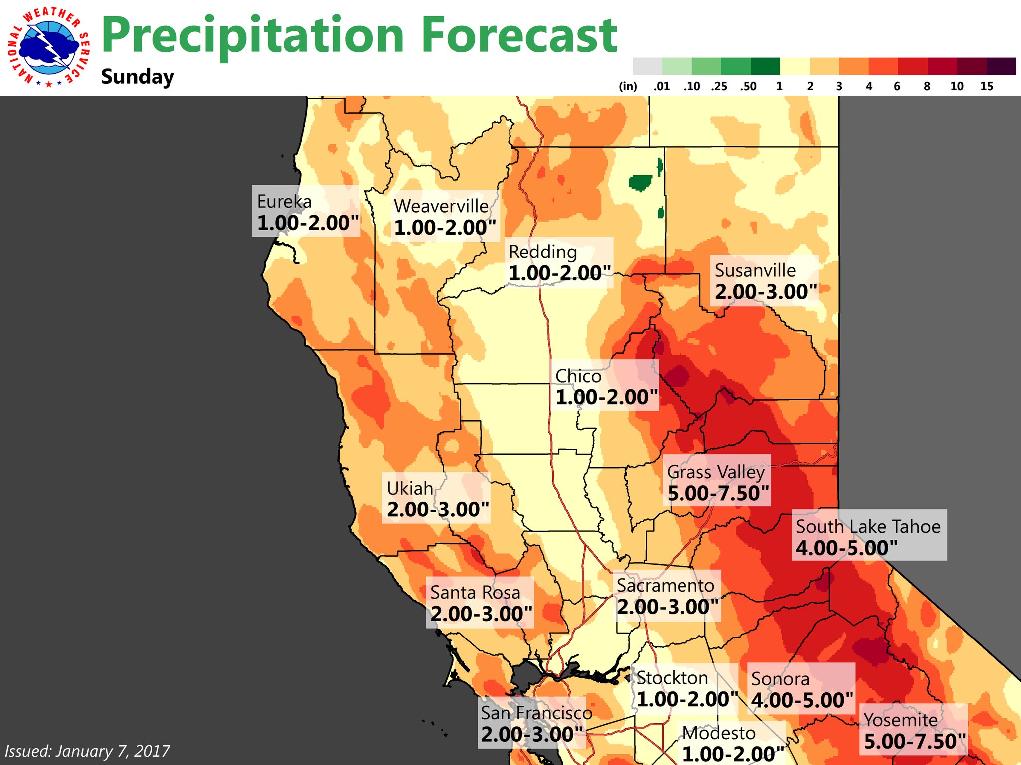
January 7, 2017 at 9:43 AM Atmospheric river inbound, heaviest rain on Sunday. Light to moderate precipitation has begun across Northern California. The brunt is still expected to arrive Saturday night and into Sunday.
January 6, 2017 at 3:33 PM Grass Valley Police: Sand and bags will be available at 556 Freeman Lane for City of Grass Valley residents. Please bring your own shovel. Sand and bags for filling are supplied.

January 6, 2017 at 10:48 AM East Main Street in Grass Valley closed at Bennett Street for fire activity.
January 6, 2017 at 8:45 AM A series of Pacific storms will plow into California over the next several days bringing several periods of heavy rain especially to the central part of the state. Since these storms will be tapping into a moist Atmospheric River…they will contain plenty of moisture so heavy precipitation is likely. The heaviest precipitation is expected to fall between Saturday evening and Monday afternoon. Another round is expected the middle of next week.
January 5, 2017 at 6:35 PM From Grass Valley Police: Third suspect identified in Grass Valley armed robbery/vehicle pursuit case
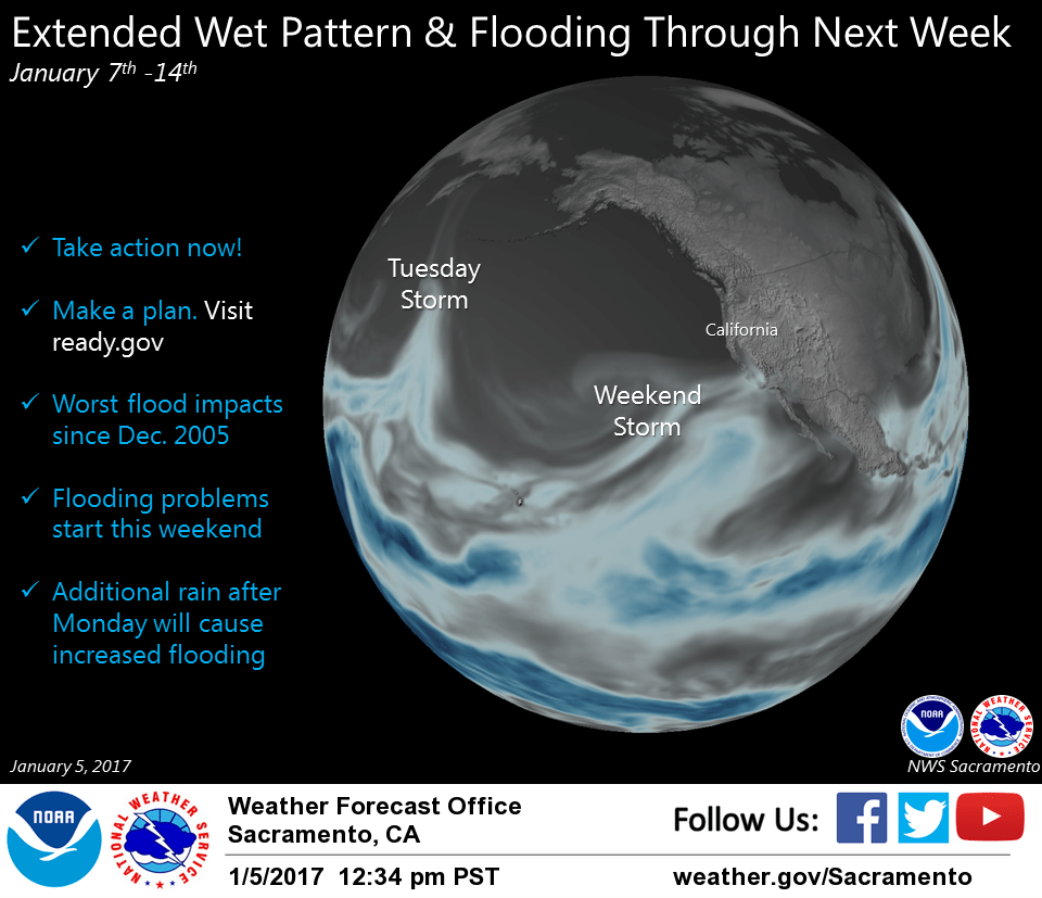
January 5, 2017 at 1:45 PM The National Weather Service in Sacramento has provided an updated briefing on this weekend’s atmospheric river and its forecast impact. The big news: Potentially more and sustained precip following the main event throughout the week.
January 5, 2017 at 10:53 AM Yuba County OES: Voluntary evacuation notices going out to handful of Yuba County homes/businesses in flood-prone area
January 5, 2017 at 10:52 AM Quick update from Caltrans on Hwy 20 between Nevada City and the I-80 junction: The Drought/Bark Beetle damaged/dying/dead tree removal project on Hwy 20 from Missouri Bar Road to Harmony Ridge Road is taking advantage of the clear weather so one way traffic controls will be in effect today and all day tomorrow as they can now work more safely since, because of the lower elevation and recent rains in the area, there is no longer snow on the branches of the trees that could impact the workers. Also, Hwy 20 is open with no chain controls (though they’re preventing single axle trucks pulling double trailers from heading up 20 to access I-80 cause those kinds of trucks are having difficulty getting up and over Donner Pass).
January 5, 2017 at 8:46 AM Brief dry period today and Friday, weekend atmospheric river to bring heavy rain. Northern California will see a break in precipitation today and Friday. Only the Sierra will see some light shower activity today. Rain and mountain snow will return on Saturday as tropical moisture starts working its way back into northern California. Snow levels will start out moderate so mountain travel may be impacted. Snow levels will rise Saturday night as precipitation rates increase. Flooding may become an issue over much of the north state as rainfall amounts accumulate over already saturated ground.
January 5, 2017 at 8:14 AM Accident in Wold Road, approximately 1/4 mile up from Hwy 49. Passenger car 40 ft down the embankment. Emergency services on scene. January 5, 2017 at 8:14 AM Accident in Wold Road, approximately 1/4 mile up from Hwy 49. Passenger car 40 ft down the embankment. Emergency services on scene.
January 4, 2017 at 10:31 PM Report of a rock and mudslide, with toppled trees on northbound Hwy 49 near the South Yuba bridge. Use caution in the area. CHP on site, Caltrans en route.
January 4, 2017 at 8:32 PM Incoming Atmospheric River: Storm prep tips and resources. Moderate precipitation starts Saturday (7th), but the brunt of storm will be Sunday and Monday. Majority of the precipitation will fall as rain in the mountains as snow levels rise above 8000 feet. This is going to be some of the more significant flooding we’ve seen in the past decade, areas may flood that haven’t seen impacts for several years. Use the break in the weather late Thursday and Friday to prepare.
January 4, 2017 at 8:29 PM Possible power lines down on the 18000 block of Sages Road in the San Juan Ridge area. North San Juan and CAL Fire en route.
January 4, 2017 at 5:52 PM I-80 closed until midnight – severe winter weather impacts mountain travelers.
January 4, 2017 at 5:52 PM Caltrans: Highway 89 between Squaw and Alpine, lanes blocked in both directions due to downed power line. No ETO.
January 4, 2017 at 5:37 PM Accident on Hwy 49 at Lime Kiln Road. Emergency services en route.
January 4, 2017 at 5:00 PM I-80 will remain closed until midnight at least. Power lines across the highway near Soda Springs.

January 4, 2017 at 3:47 PM Update on various power outages in the area: Pike City area, trouble men assessing damage. North San Juan at Oak Tree Rd, crew is on site. Good Years Bar area, damage being assessed. Grass Valley on Packard Drive, tree into the transmission line and a broken pole – repair crew on site. Hwy 20 at Casci Rd area, damage being assessed. PG&E crews will be working through this evening and trouble men will be accessing damaged areas throughout the night.
January 4, 2017 at 3:34 PM Non-injury accident on Hwy 49 at East Lime Kiln Road south of Grass Valley.
January 4, 2017 at 3:28 PM The bovine is back in its pasture, Lime Kiln Road is now clear again of two- and four-legged hazards.
January 4, 2017 at 3:21 PM A car slid off the embankment on Oak Tree Road in North San Juan near Robinson Road. Emergency services en route.
January 4, 2017 at 3:20 PM Watch for a cow in the roadway and the two people trying to direct traffic around her on Lime Kiln Road at Wolf Road.
January 4, 2017 at 2:42 PM Units at scene can handle the small stove fire. All incoming units to Torrey Pines Drive are canceled and reassigned.
January 4, 2017 at 2:37 PM First unit has arrived at scene on Torrey Pines Drive. Reporting white smoke showing from the chimney, they will investigate.
January 4, 2017 at 2:30 PM Report of a residential structure fire, possibly a chimney fire, on Torrey Pines in the Lakes of the Pines area. Numerous engines en route.

January 4, 2017 at 1:46 PM Per CHP Truckee: Currently all traffic on I-80 eastbound is being turned around at Nyack, westbound I-80 is only closed to Tractor Trailers.
Now, eastbound Hwy 20 is being closed at Nevada Street in Nevada City. Now, eastbound Hwy 20 is being closed at Nevada Street in Nevada City.
January 4, 2017 at 12:18 PM Power line snagged by a truck on the 16600 block of Woods Boulevard in Truckee. Never touch power lines on the ground!
January 4, 2017 at 11:59 AM Rock and mud slide on Hwy 20 at Scotts Flat Road. Westbound lane is partially blocked, some debris also in the eastbound lane. Reduce speed and use caution in the area.

January 4, 2017 at 11:54 AM Here’s a photo from Western Gateway park in Penn Valley by Kyla Halford. Be careful out there!
January 4, 2017 at 9:53 AM Madelyn Helling Library closed today due to power outage, all other county buildings are open.
January 4, 2017 at 9:53 AM North Tahoe Fire: The power is currently out in the area of McKinney creek rd and Robin rd along the west shore. Be cautious of low hanging power lines.
January 4, 2017 at 8:38 AM A Waste Management truck just had a close encounter with a power pole on Nugget Lane in Grass Valley. Emergency services en route.
January 4, 2017 at 8:33 AM Grizzly Hill School is out of power. School resumes Thursday.
January 4, 2017 at 8:18 AM CHP Gold Run: I-80 traffic is no longer being held. Chain control has been moved to Kingvale.
January 4, 2017 at 8:14 AM 714 customers are without power in the Alleghany, Sierra City to Haskell Creek area. PG&E is assessing the cause at the outage location.
January 4, 2017 at 8:13 AM Camptonville and Pike are still without power, 383 homes affected. PG&E has assigned a crew to assess the outage.
January 4, 2017 at 8:10 AM 237 homes without power in North San Juan in an area from Pleasant Valley Road, Sweetland Road down to Oak Tree and Milky Way. PG&E assessment crew is en route to the outage.
January 4, 2017 at 8:08 AM 361 customers without power due to a broken pole in the Condon Park area in Grass Valley. Affecting Butler Rd, Packard Drive, Primrose Lane and Minnie Street. PG&E repair crew is on-site working to restore power, estimated time of restoration is 9:00 am.
January 4, 2017 at 8:05 AM 218 homes affected by a broken pole, power is out on portions of Spring Street, West Broad and Chief Kelly Drive in Nevada City. PG&E is sending a repair crew to the outage location, no estimated time of restoration yet.
January 4, 2017 at 7:51 AM Mainly wet week ahead, dry on Friday, very heavy rain Sunday-Monday. A feed of subtropical moisture into northern California will keep a mainly wet pattern going over Norcal for the coming week. Today’s system will bring snow over the Sierra through this evening with decreasing showers expected Thursday. Friday will see a break in the precipitation before another round of precipitation hits the north state over the weekend and into early next week. Sunday and Monday look to be the wettest days with high snow levels combining with heavy precipitation to bring another round of possible local flooding. Precipitation continues for the middle of next week but with lower snow levels.
January 4, 2017 at 7:41 AM Caltrans: US Hwy50 R-2 Chain Control to Meyers. Expect delays. Eastbound traffic being held at Echo and Westbound at Meyers for Avalanche control.

January 4, 2017 at 7:40 AM CHP Truckee: Currently I-80 is closed in both directions due to extremely low visibility and snow.
January 4, 2017 at 7:39 AM A mud and rock slide is blocking one lane on Dog Bar Road near Springfield Drive.
January 3, 2017 at 11:51 PM The high winds are causing multiple power outages in the Foothills. PG&E trouble crews are working to identify and assess damage to facilities and power lines to make them safe. Please call 1-800-743-5000 to report problems. Please, stay clear of all lines. They could possibly be energized, even phone or cable lines. Stay safe and spare a thought for the line crews out in these conditions to repair and restore power lines.
January 3, 2017 at 8:54 PM No estimated time of restoration available yet for a power outage affecting 650 homes in the Pasquale Road to Red Dog via Cascade Shores area of Nevada City. 215 customers remain without power from Cooper Road to White Cloud on Hwy 20. North Columbia, Camptonville, Downieville also remain without power. Forbestown, Frenchtown, portions of Challenge and Brownsville up to Laporte are expected to have power restored by 10 pm tonight.
January 3, 2017 at 1:48 PM Pursuit has ended in Sacramento. Three suspects apparently in the van, one has been arrested. Details to follow.
January 3, 2017 at 1:26 PM Truckee Police: Traffic is once again heavy westbound on I-80 and all side streets. While it is only snowing lightly, traffic is backed up throughout Town. Limit non-essential trips for now. If driving, remember patience and please use common courtesy. Cutting people off, driving on the shoulder, and blocking intersections does not help traffic flow smoothly.
January 3, 2017 at 12:48 PM Pursuit still ongoing, suspect vehicle now on Hwy 70 towards Sacramento with law enforcement in pursuit. Two suspects, suspected to be armed, in the vehicle.
January 3, 2017 at 12:24 PM Law enforcement in pursuit of a vehicle on Hwy 20 at the Nevada/Yuba county line. Direction of travel is towards Yuba County. Use caution in the area.
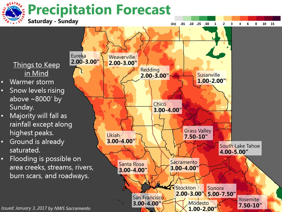
January 3, 2017 at 12:21 PM National Weather Service: After Thursday, a warmer atmospheric river will bring higher snow levels & heavy rain this weekend. Heightened concern for flooding.
January 3, 2017 at 11:17 AM Two outages affecting 62 homes in the You Bet area. Estimated time of restoration unknown.

January 3, 2017 at 11:12 AM Power outage affecting Cascade Shores, Red Dog Road and portions of Banner Lava Cap Road in Nevada City. 752 homes affected. Also a smaller outage, affecting 70 people, on Boulder Street from Park Ave to the end of the road.
January 3, 2017 at 10:55 AM Water flow alarm sounding at the storage facility on Spring Hill Drive, across from Idaho-Maryland Road in Grass Valley. Emergency services en route.
January 3, 2017 at 9:58 AM Accident on Rough&Ready Hwy near Rex Reservoir. Truck driver reports an overturned vehicle in a ditch. CHP en route.
January 3, 2017 at 9:54 AM Reported accident near Hwy 20 turns out to be an abandoned vehicle from last night. Canceling all response.
January 3, 2017 at 9:44 AM Overturned vehicle on Hwy 20 eastbound at McCourtney in Grass Valley. Emergency services en route.
January 3, 2017 at 9:31 AM Traffic hazard, vehicle stuck in the middle of the roadway on Red Dog Road near the intersection with Pasquale Road in Nevada City.
January 3, 2017 at 9:27 AM Gold Country Transit Service: Buses are running. Gold Country Transit Services’ office is located near the airport, getting to the office is no easy feat today. But Transit Manager Susan Healy-Harmon confirms all bus routes are in service today. “We may be running a little late, but all services are running,” Healy-Harmon said. “We’re playing it by ear for now.”
January 3, 2017 at 8:33 AM Report of 1 ft of snow in Cascade Shores – and still snowing!
January 3, 2017 at 7:31 AM Power outage on Sages Road on the San Juan Ridge is affecting 46 homes.
January 3, 2017 at 7:26 AM Placer County Office of Education reports school closures for today: Alta Dutch and all Tahoe Truckee Unified schools. Be safe out there!
January 3, 2017 at 7:18 AM Tree in the roadway on the 15200 block of Banner Lava Cap in Nevada City. Emergency services en route.
January 3, 2017 at 7:15 AM Very heavy rain and snow through Thursday, flood watch issued. Several feet of additional snowfall accumulation expected across the NorCal mountains into Thursday. Mountain travel is discouraged.
January 3, 2017 at 6:58 AM Power outages in Camptonville affecting over 400 people. Another outage affecting 73 homes in North Columbia and an outage from the town of Washington to Sierra City, Bassetts and Haskell Creek is affecting 1,237 homes. No estimated time of restoration yet.
January 3, 2017 at 6:45 AM With the exception of Alta Sierra, Cottage Hill, Magnolia and Penn Valley, all other western Nevada County schools are closed due to snow.
January 2, 2017 at 7:36 PM Firefighters have extricated the driver from the vehicle on Bitney Springs and are evaluating the patient now.
January 2, 2017 at 7:16 PM Vehicle rollover, possible extrication required, on Bitney Springs Road past the Nevada City School of the Arts. Emergency services are en route.

January 2, 2017 at 5:40 PM Caltrans: I-80
HELD: Westbound at Truckee
HELD: Westbound at Boca
HELD: Eastbound at Castle Peak, (@ DRA Holding only)
CLOSED: Eastbound at Alta
January 2, 2017 at 5:18 PM The power outage due to a vehicle accident on Red Dog Road is affecting 868 people, including Quaker Cross Hill and the south side of Cascade Shores. PG&E crews are on scene.
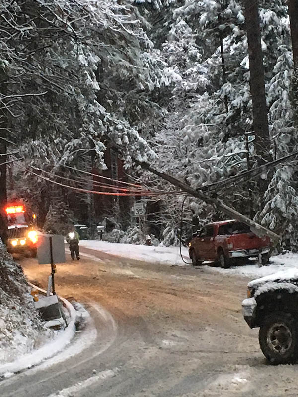
Estimated time of restoration at this point is 7 pm. Please avoid Red Dog Road, the road is closed as the pole and power lines are hanging over the roadway.
January 2, 2017 at 4:18 PM Thanks to reader Carolyn for reporting a power outage on Banner in Nevada City. Turns out, this is related to an accident on Red Dog Road near Pasquale – a truck into a power pole. Lines are on the vehicle, with driver inside. Emergency services on scene.
January 2, 2017 at 3:35 PM Avoid Ridge Road in Nevada City, hasn’t been plowed in a while. Thanks Steve for the tip. Also, accident on Banner Lava Cap.
January 2, 2017 at 3:28 PM Solo vehicle accident on North Bloomfield Road just outside Nevada City. No injuries reported.
January 2, 2017 at 3:26 PM Several cars stuck in the snow on Brunswick Road and Loma Rica Drive in Grass Valley. If you don’t have to be on the road, stay home!
January 2, 2017 at 3:24 PM Vehicle accident, extrication required, on Hwy 49 near La Barr Meadows Road in Grass Valley. Emergency services en route.
January 2, 2017 at 3:21 PM Eastbound traffic on Hwy 20 is being shut down at Nevada City.
January 2, 2017 at 2:50 PM Chain control for Hwy 20 now in Nevada City at Nevada Street.
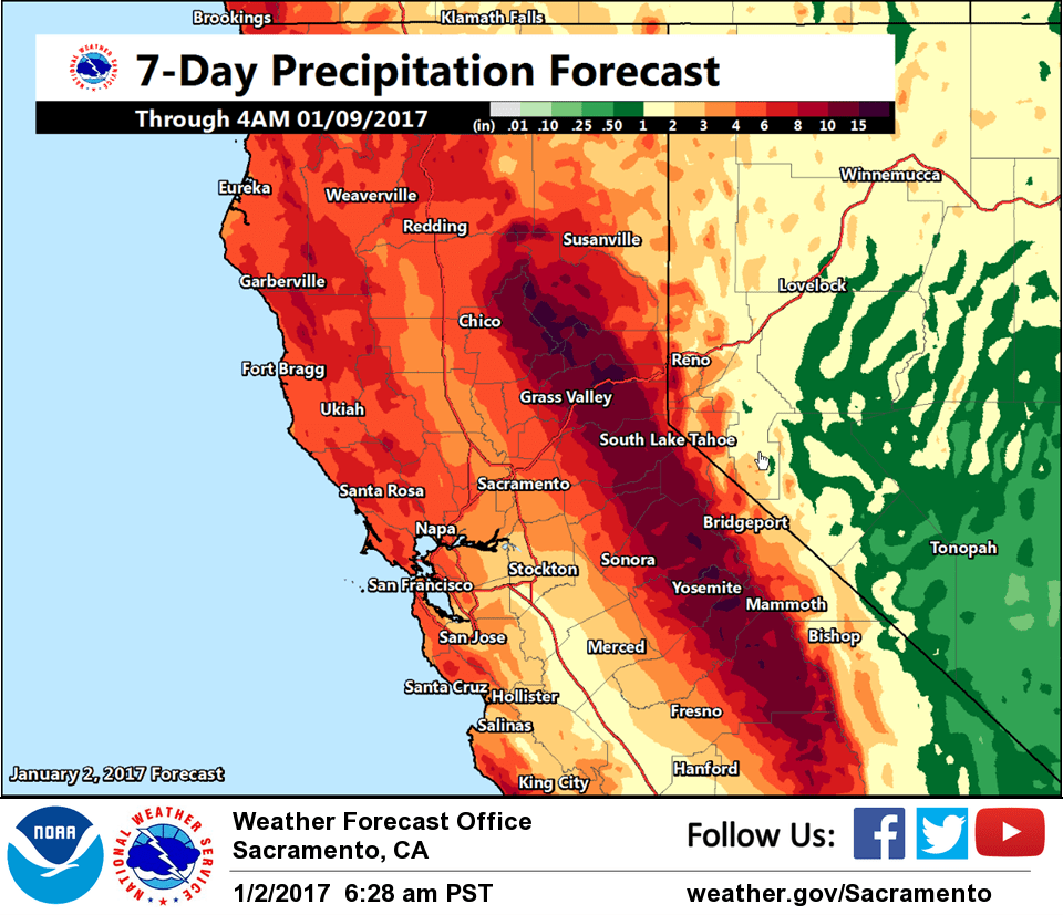
January 2, 2017 at 2:44 PM Flood watch in effect from Tuesday evening through Wednesday night. A total 4 to 7 inches of rain is expected through early Thursday with the heaviest totals over the western slopes of the Sierra Nevada Tuesday evening through Wednesday night.
January 2, 2017 at 12:48 PM Report of an armed robbery at the Smoke Shop on Colfax Ave in Grass Valley.
January 2, 2017 at 9:34 AM Caltrans: Chain control I-80 from Colfax the state line both directions. The snow is very wet and slippery, slow down.
January 2, 2017 at 9:29 AM Hwy 49 at La Barr Meadows in Grass Valley, Caltrans will be out plowing shortly. Watch for equipment, slow down and leave extra distance between cars.
January 2, 2017 at 7:53 AM Low snow levels today and tomorrow, generally wet week ahead. Colder air has arrived across NorCal with low-elevation snow down to the foothills. Significant snow accumulations are likely today and Tuesday with mountain travel delays. Models continue to show a wet, but milder pattern for Wednesday into at least next weekend resulting in additional rain and mountain snow. Details are likely to change so stay tuned!
January 1, 2017 at 10:36 PM I-80 westbound is closed at Truckee due to heavy snow and numerous accidents.
January 1, 2017 at 8:38 PM Happy New Year from the crew at NWS Sacramento. For this first day of 2017, we bring you a forecast of colder weather with rain and snow today through Tuesday followed by more wet weather in the latter half of the week.
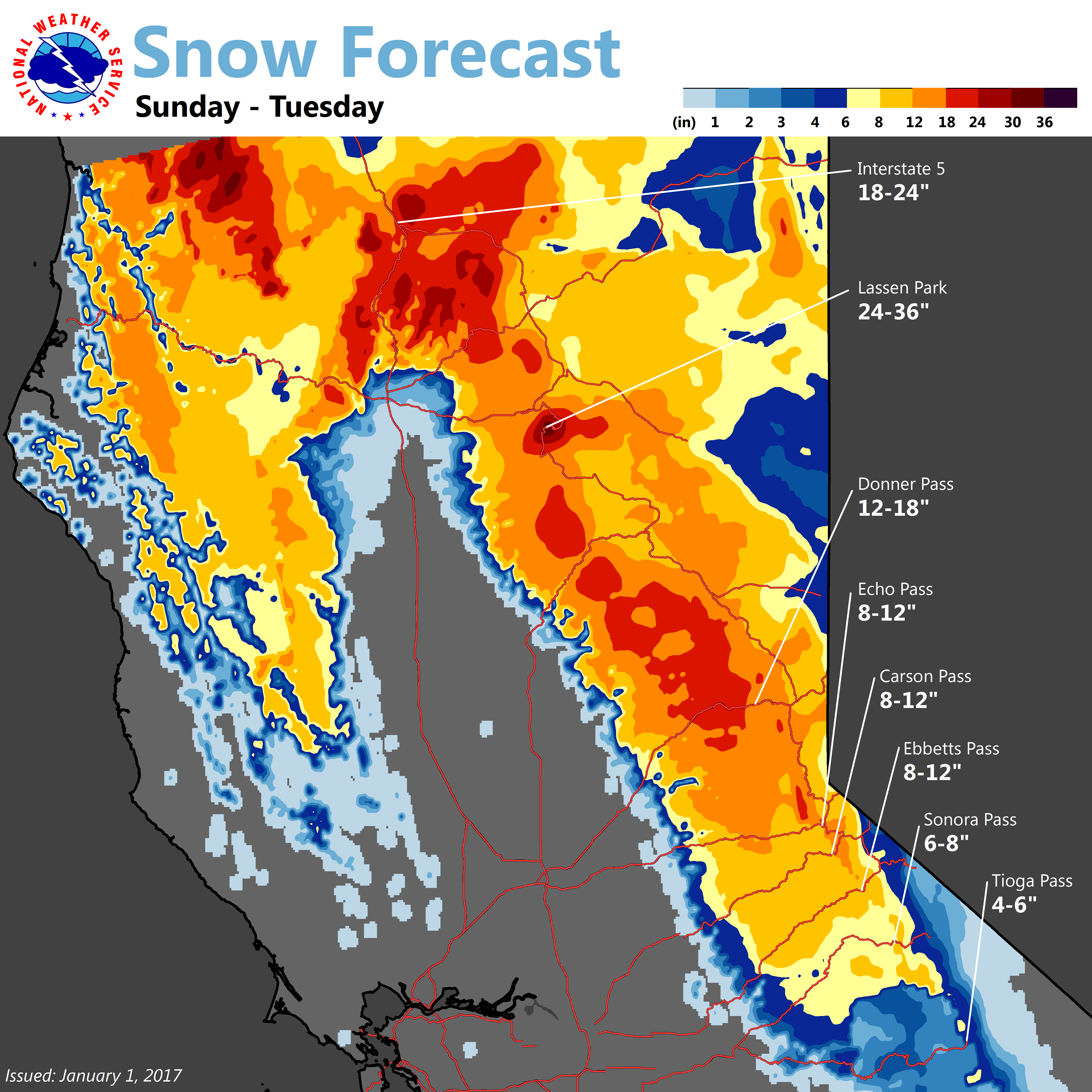
Scattered showers are already impacting the NorCal coastline and they are beginning to cross over the Coastal Range into interior NorCal. This storm is also bringing a much colder airmass as it impacts our region. The coldest air should arrive tonight through Monday morning causing low snow levels. Across the Coastal Range and western Sierra slopes, snow levels will lower into the foothills (1000 to 3000 feet) where we expect the heaviest snow accumulations to occur above 2000 feet. However, the lowest snow levels are expected in Shasta County between 500 to 1000 feet which would impact the Redding vicinity. Here’s the tricky part of the forecast for Redding: models have been trending a little warmer and raising snow levels, but cold air from the Shasta County mountains is likely to drain into the Northern Sacramento valley near Redding and that cold air could get trapped. Therefore, if any showers occur near Redding, it would fall as snow if that cold air is in place. However, if the winds are just right and mix out the cold air or warm air overtakes the colder air, then precipitation would fall as rain instead. It’s one of those scenarios where if the puzzle pieces all fit together at the right time, then we could have snow near or even in Redding. To make sure people are prepared for this possibility, we have gone ahead and issued a Snow Advisory for the Northern Sacramento Valley from tonight through Monday morning. We have also put up a Snow Advisory along with the foothills of the Coastal Range & Sierra from now through Tuesday matching the current Advisory for the higher elevations. In general, snow accumulations should peak between 1 to 2 feet over higher elevations above 3000 feet with 1 to 8 inches across the foothills between now through Tuesday night
From Tuesday night into Wednesday, models are showing a warmer and much wetter pattern as another surge of moisture moves into our CWA. Snow levels will rise becoming 3500-5000 feet for most of our forecast area except in Shasta County where they could be 2500-3500 feet. The Sierra could see an additional 4-12 inches of snow on Wednesday into early Thursday.

January 1, 2017 at 6:53 PM Snow is creating hazardous driving conditions on I 80 near the summit and down to Whitmore Grade. Carry chains and be prepared for delays. Chain control at Alta and Donner Lake at this time.
January 1, 2017 at 3:29 PM Report of a roadside fire on Combie Road in Lake of the Pines. Emergency services en route.

January 1, 2017 at 2:26 PM The National Weather Service in Sacramento has issued a winter weather advisory for snow, which is in effect until 10 pm Tuesday.
Main impact: Hazardous winter travel down to low elevations with reduced visibility, chain controls and traffic delays likely over the mountains.
Timing: Light to moderate snow showers expected today through Tuesday.
Locations: Grass Valley, Placerville, Colfax, Camino, Interstate 80, Highway 50 and 88.
Snow accumulations: Heaviest snow expected above 2000 feet ranging 3 to 8 inches north of Interstate 80 and 1 to 6 inches south of Interstate 80. A dusting of snow possible as low as 1000 feet.
January 1, 2017 at 11:24 AM Sierra Roots is opening the warming shelter at Seaman’s Lodge in Nevada City today, starting at 4:00 pm. The shelter will remain open through the week.
January 1, 2017 at 11:15 AM Wet week ahead, low snow levels tonight and Tuesday. Colder air will arrive for the beginning of this week, with low elevation snow down towards the foothills, possibly even into the higher elevations of the Valley near Redding. Significant snow accumulations are possible Monday and Tuesday with travel delays likely. Models continue to show a wet, but warmer pattern for Wednesday into at least next weekend, which means additional rain and mountain snow, but warmer overnight temperatures. Details are likely to change so stay tuned!
January 1, 2017 at 12:01 AM – If you are looking for last month’s log, you can find it here. The featured image is a Red Tail Hawk who visited YubaNet HQ on Christmas.
January 1, 2017 at 12:00 AM – Wishing you a Happy, Healthy and Prosperous New Year!
-Susan and Pascale